IMAGES TAKEN NEAR TO
Bromley Street, MANCHESTER, M4 4JS
Introduction
This page details the photographs taken nearby to Bromley Street, M4 4JS by members of the Geograph project.
The Geograph project started in 2005 with the aim of publishing, organising and preserving representative images for every square kilometre of Great Britain, Ireland and the Isle of Man.

There are currently over 7.5m images from over14,400 individuals and you can help contribute to the project by visiting https://www.geograph.org.uk
Image Map
Images are licensed for reuse under creativecommons.org/licenses/by-sa/2.0
Notes
- Clicking on the map will re-center to the selected point.
- The higher the marker number, the further away the image location is from the centre of the postcode.
Image Listing (202 Images Found)
Images are licensed for reuse under creativecommons.org/licenses/by-sa/2.0
Image
Details
Distance
1
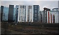
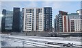
Bromley Street
Bromley Street within the stalled Angelgate development.
Image: © Peter McDermott
Taken: 4 Aug 2016
0.00 miles
2
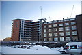
Angelgate Development
The stalled 'Angelgate' development on Dantzic Street in Manchester. The developer is Pinnacle, architect is BLOK and the builder was PHD1 construction although they no longer seem to be associated with the project.
Image: © Peter McDermott
Taken: 28 Mar 2016
0.04 miles
3

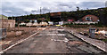
The Love Factory
Old industrial building on Dantzic Street used for occasional music festivals.
Image: © Peter McDermott
Taken: 29 Nov 2021
0.05 miles
4

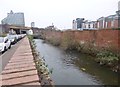
A Glimpse of the Irk
The River Irk has been tamed by brick walls, probably for over a century. However nature is making a determined effort to reclaim it. This shot was one of the few glimpses available over a wall and between the buddleia bushes. Taken looking downstream.
Image: © Glyn Baker
Taken: 10 Sep 2021
0.05 miles
6
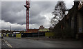
Newtown, River Irk
Looking downstream from Dantzig Street. The river rises in Royton, and joins the Irwell in the city centre. http://manchesterhistory.net/manchester/WATERWAYS/irk/riverirk.html
Image: © Mike Faherty
Taken: 26 Dec 2014
0.05 miles
7
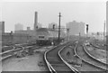
Trans-Pennine DMU on Miles Platting bank
A Hull-Liverpool train approaches Manchester Victoria. Built as 6-car sets, the Trans-Pennine units' buffet cars were withdrawn in the early 1970s, leaving the formation apparent in the photograph. Manchester Victoria's immediate surroundings were still largely industrial in the 1970s. "Urban living" apartments have now replaced the chimney visible.
Image: © Peter Whatley
Taken: Unknown
0.06 miles
8
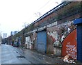
Bromley Street - Collyhurst, Manchester
Image: © Anthony Parkes
Taken: 3 Jan 2016
0.06 miles