1
Angel Meadows
Image: © Peter McDermott
Taken: 11 Apr 2021
0.01 miles
2
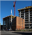
One, Angel Square
Looking from Aspin Lane towards "1, Angel Square" - the first phase of 53ºNOMA a large mixed-use development which is due to open later in 2012 and will be home to The Co-operative Group. NOMA is an acronym for NO(rth) MA(nchester) and 53º is the area's latitude co-ordinate.
See http://en.wikipedia.org/wiki/NOMA,_Manchester for more information about NOMA.
Image: © David Dixon
Taken: 15 Mar 2012
0.02 miles
3
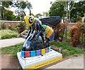
Cottonopolis, Angel Meadow
Cottonopolis is bee#14 in the Bee in the City sculpture trail, It is positioned at the side of Angel Street, next to the steps leading to Angel Meadow. The design, created by Leah Pendleton, focuses on Manchester’s industrial heritage and is intended to be “a visual metaphor for the way cotton is woven into the fabric of the city”. The black background alludes to the smoky skies that hung over Manchester in its ‘Cottonopolis’ heyday. The patterns appear to have a woven, tactile texture whilst pools of bold, coloured cotton weave around the shape of the bee.
Image: © David Dixon
Taken: 6 Aug 2018
0.02 miles
4
Angel Meadow
What is now a pleasant city park between Aspin Lane and Old Mount Street was once the churchyard of St Michael's and All Angels Church which was built in 1788 and stood until 1935. It was originally built as a carriage church for wealthy Mancunians from the town, or for those who had taken up residence in the more fashionable houses of the area. Prior to its construction the Overseers of the Poor of Manchester had purchased the land adjoining the churchyard for use as a parochial Burial Ground to cater for the high rates of mortality that resulted from the overcrowded slum conditions of the area; a big influence on the philosopher Friedrich Engels who famously wrote about the pauper burial grounds in Manchester in his account of the Condition of the Working Classes in England (1844).
The “new Burying Ground”, or “The Flags” as it later became known, was consecrated in 1787 to serve the grossly overcrowded Angel Meadow area and was the largest cemetery in Manchester. It was used for burying paupers who had no money for a proper burial. By 1816 the burial ground was full and closed down. Covered in flagstones, it then became a children's playground known as “St Michael’s Flags”. It has been estimated that there were more than 40000 bodies beneath the flags which remained in place until they were removed in 2001 when the site was renovated to create the park we see today.
More information and photos at Manchester History Net http://manchesterhistory.net/manchester/tours/tour16/area16page8.html and Wikipedia http://en.wikipedia.org/wiki/St_Michael's_Flags_and_Angel_Meadow_Park .
Image: © David Dixon
Taken: 6 Aug 2018
0.02 miles
5
Cottonopolis
Located at the side of Angel Street, next to the steps leading to Angel Meadow, Cottonopolis was created by Leah Pendleton and sponsored by Meadow Side.
"The design focuses on Manchester’s industrial heritage and is a visual metaphor for the way cotton is woven into the fabric of the city. The black background alludes to the smoky skies that hung over Manchester in its 'Cottonopolis' heyday. The patterns appear to have a woven, tactile texture whilst pools of bold, coloured cotton weave around the shape of the Bee."
MeadowSide is a mix of apartments, townhouses and penthouses on the edge of the park.
Image: © Gerald England
Taken: 5 Sep 2018
0.03 miles
6
Here comes the sun.
Solar powered street lighting along a path at Angel Meadow and St Michael's Flags.
http://en.wikipedia.org/wiki/St_Michael%27s_Flags_and_Angel_Meadow_Park
Image: © Keith Williamson
Taken: 14 Dec 2005
0.03 miles
7
St Michael's Flags & Angel Meadow
Information board near the entrance on Angel Street.
Angel Meadow was consecrated in 1787 to serve the grossly overcrowded Angel Meadow area and was the largest cemetery in Manchester. Next to the Parochial Burial Ground St Michael's and All Angels Church was built in 1788 and stood until 1935. It was used for burying paupers who had no money for a proper burial. By 1816 the burial ground was full and closed down. Covered in flagstones, it then became a children's playground known as "St Michael's Flags". The flags remained in place until they were removed in 2001 when the site was renovated to create the park we see today.
More information and photos at Manchester History Net http://manchesterhistory.net/manchester/tours/tour16/area16page8.html and Friends of Angel Meadow http://www.friends-of-angel-meadow.org/page26.htm
Image: © Gerald England
Taken: 5 Sep 2018
0.03 miles
8
Meadow Side
The Meadow Side development in Manchester.
Image: © Peter McDermott
Taken: 19 Apr 2020
0.03 miles
9
Angel Meadow/St Michael's Flags
This pleasant city park between Aspin Lane and Old Mount Street is divided by an old wall. The land between this wall and Angel Street was once the churchyard of St Michael's and All Angels Church which was built in 1788 and stood until 1935. The rest of the land was the Parochial Burial Ground.
The “new Burying Ground”, or “The Flags” as it later became known, was consecrated in 1787 to serve the grossly overcrowded Angel Meadow area and was the largest cemetery in Manchester. It was used for burying paupers who had no money for a proper burial. By 1816 the burial ground was full and closed down. Covered in flagstones, it then became a children's playground known as “St Michael’s Flags”. The flags remained in place until they were removed in 2001 when the site was renovated to create the park we see today. More information and photos at Manchester History Net http://manchesterhistory.net/manchester/tours/tour16/area16page8.html and Wikipedia http://en.wikipedia.org/wiki/St_Michael's_Flags_and_Angel_Meadow_Park .
Image: © David Dixon
Taken: 15 Mar 2012
0.04 miles
10
Manchester, Aspin Lane
Street scene of Aspin Lane, near Victoria Station, showing brick wall which bears an OS benchmark - see http://www.geograph.org.uk/photo/1858211
Image: © Roger Templeman
Taken: 2 Apr 2010
0.04 miles


