IMAGES TAKEN NEAR TO
Naples Street, MANCHESTER, M4 4AR
Introduction
This page details the photographs taken nearby to Naples Street, M4 4AR by members of the Geograph project.
The Geograph project started in 2005 with the aim of publishing, organising and preserving representative images for every square kilometre of Great Britain, Ireland and the Isle of Man.

There are currently over 7.5m images from over14,400 individuals and you can help contribute to the project by visiting https://www.geograph.org.uk
Image Map
Images are licensed for reuse under creativecommons.org/licenses/by-sa/2.0
Notes
- Clicking on the map will re-center to the selected point.
- The higher the marker number, the further away the image location is from the centre of the postcode.
Image Listing (971 Images Found)
Images are licensed for reuse under creativecommons.org/licenses/by-sa/2.0
Image
Details
Distance
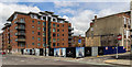
1
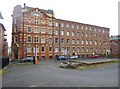
Manchester, CWS Printing Works
On New Mount Street, later transferring to Longsight; now residential and business units. http://manchesterhistory.net/manchester/tours/tour12/coopprint.html
Image: © Mike Faherty
Taken: 26 Dec 2014
0.02 miles
2
Halo
The Halo development, a 6 storey residential development comprising of 66 one, two and three bed apartments with basement car parking.
Image: © Peter McDermott
Taken: 1 May 2017
0.03 miles
3

Halo
The 'Halo' development between School Street and New Mount Street.
Image: © Peter McDermott
Taken: 25 Jun 2017
0.04 miles
4

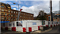
Cooperative Printing Society Ltd
The old goods entrance to the Cooperative Printing Society Ltd on School Street.
Image: © Peter McDermott
Taken: 25 Jun 2017
0.04 miles
5
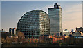
The Cooperative
The new and the old Cooperative HQ buildings in Manchester.
Image: © Peter McDermott
Taken: 6 Apr 2013
0.04 miles
6
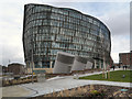
Co-Operative Group, One Angel Square
The newly completed headquarters for the Co-operative Group. The large structures in front of the building are the three huge “earth tubes” that pull in the air for circulation around the building, functioning both as a sculpture and an environmentally-friendly heating and ventilation system for the entire vast structure.
Image: © David Dixon
Taken: 12 Apr 2013
0.04 miles
7
North Central
The North Central development.
Image: © Peter McDermott
Taken: 1 May 2017
0.04 miles
8
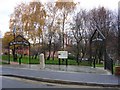
Angel Meadow and St Michael's Flags
Situated in Manchester's Northern Quarter, not far from the Cathedral, this pleasant green area has an interesting history, told on information boards around the site. Once the site of a church, a pauper's/plague burial ground and, reputedly, Manchester's worst slums. An estimated 40,000 bodies were buried here between 1787 and 1816. Some details here: http://en.wikipedia.org/wiki/St_Michael's_Flags_and_Angel_Meadow_Park
Image: © Keith Williamson
Taken: 14 Dec 2005
0.05 miles
9
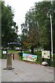
St Michaels Flags
The St Michaels gate to an urban park. See also Image and read about its history at https://en.wikipedia.org/wiki/St_Michael%27s_Flags_and_Angel_Meadow_Park
Image: © Glyn Baker
Taken: 10 Sep 2021
0.05 miles
10
Angel Meadows
Commercial buildings converted to flats near Angel Meadows Park.
Image: © Peter McDermott
Taken: 5 Jul 2014
0.05 miles