IMAGES TAKEN NEAR TO
Roseway Avenue, MANCHESTER, M44 5GG
Introduction
This page details the photographs taken nearby to Roseway Avenue, M44 5GG by members of the Geograph project.
The Geograph project started in 2005 with the aim of publishing, organising and preserving representative images for every square kilometre of Great Britain, Ireland and the Isle of Man.

There are currently over 7.5m images from over14,400 individuals and you can help contribute to the project by visiting https://www.geograph.org.uk
Image Map
Images are licensed for reuse under creativecommons.org/licenses/by-sa/2.0
Notes
- Clicking on the map will re-center to the selected point.
- The higher the marker number, the further away the image location is from the centre of the postcode.
Image Listing (35 Images Found)
Images are licensed for reuse under creativecommons.org/licenses/by-sa/2.0
Image
Details
Distance
1
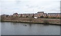
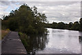
Hayes Green
On the north bank of the Manchester Ship Canal.
Image: © Christine Johnstone
Taken: 13 Apr 2013
0.10 miles
2
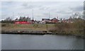
Hayes Green, western end
Redrow and Wimpey seem to be involved in this new housing development on the north bank of the Manchester Ship Canal.
Image: © Christine Johnstone
Taken: 13 Apr 2013
0.10 miles
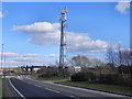
3
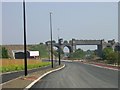
Not on the map yet!
Looking northeastwards along the newly constructed Cadishead Way (Phase II). Phase One by-passed Irlam and carried the A57 away from the town by the banks of the Manchester Ship Canal. This section extends the road, by-passing Cadishead and rejoining the "old road" on the Cheshire border with Salford by the River Glaze. The large bridge used to carry a railway line which has been dismantled and is blocked using containers to prevent people using it as a crossing! The new tunnel for the road was constructed by removing the embankment inserting the tunnel structure then backfilling. Perhaps the rails will return one day! SJ71269191
Image: © Keith Williamson
Taken: 4 Sep 2005
0.10 miles
4
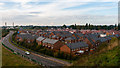
Cadishead
New housing development at Cadishead.
Image: © Peter McDermott
Taken: 11 Oct 2014
0.11 miles
6
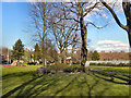
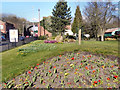
Cadishead Park
The park off Liverpool Road in Cadishead.
Image: © David Dixon
Taken: 18 Mar 2011
0.14 miles
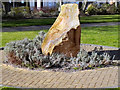
7
Cadishead Park
Cadishead Park, off Liverpool Road.
Image: © David Dixon
Taken: 18 Mar 2011
0.14 miles
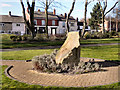
10
Cadishead Park
Cadishead Park, Liverpool Road, Cadishead.
Image: © David Dixon
Taken: 18 Mar 2011
0.15 miles