IMAGES TAKEN NEAR TO
Quinn Square, M43 6US
Introduction
This page details the photographs taken nearby to Quinn Square, M43 6US by members of the Geograph project.
The Geograph project started in 2005 with the aim of publishing, organising and preserving representative images for every square kilometre of Great Britain, Ireland and the Isle of Man.

There are currently over 7.5m images from over14,400 individuals and you can help contribute to the project by visiting https://www.geograph.org.uk
Image Map
Images are licensed for reuse under creativecommons.org/licenses/by-sa/2.0
Notes
- Clicking on the map will re-center to the selected point.
- The higher the marker number, the further away the image location is from the centre of the postcode.
Image Listing (191 Images Found)
Images are licensed for reuse under creativecommons.org/licenses/by-sa/2.0
Image
Details
Distance
1
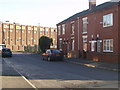
Gorseyfields and Robertsons
On the right are five houses, with only four shown. In 1914 they were in the ownership of Mr J Cooke, in what was then Union Street. The Holmes family were renting the middle property and did so until my Grandmother's death in 1963.
Image: © Paul Holmes
Taken: 13 Feb 2008
0.03 miles
2
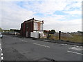
Ashton Hill Lane, Droylsden
All that's left of Robertsons Jam Works.
Image: © John Topping
Taken: 27 Sep 2012
0.03 miles
3
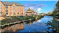
New build housing at Fairfield
Beside Ashton Canal
Image: © Chris Morgan
Taken: 4 Nov 2022
0.04 miles
4
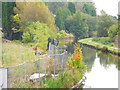
Ashton Canal, Droylsden
Looking east from Ashton Hill Lane bridge, with a Heron on the metal fence.
Image: © John Topping
Taken: 27 Sep 2012
0.04 miles
6
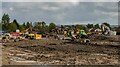
Ashton Hill Lane
Excavators on a demolition site of Ashton Hill Lane in Fairfield.
Image: © Peter McDermott
Taken: 30 Nov 2014
0.06 miles
7
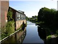
Ashton Canal, Droylsden
Looking in an easterly direction along the Ashton Canal at Droylsden by the side of the Robertson's Jam Factory. SJ90469766.
Image: © Keith Williamson
Taken: 28 Sep 2005
0.07 miles
8
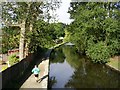
Morning Jog.
A lone jogger running westwards along the Ashton Canal at Droylsden. SJ90469766.
Image: © Keith Williamson
Taken: 28 Sep 2005
0.07 miles
9
Corseyfields, Droylsden
Looking northwest from Ashton Hill Lane.
Image: © John Topping
Taken: 27 Sep 2012
0.07 miles
10
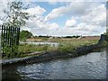
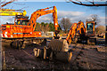
Flooded demolition site, north bank, Ashton Canal
Mapped as 'a works'.
Image: © Christine Johnstone
Taken: 9 May 2014
0.08 miles