IMAGES TAKEN NEAR TO
Southway, MANCHESTER, M43 6EH
Introduction
This page details the photographs taken nearby to Southway, M43 6EH by members of the Geograph project.
The Geograph project started in 2005 with the aim of publishing, organising and preserving representative images for every square kilometre of Great Britain, Ireland and the Isle of Man.

There are currently over 7.5m images from over14,400 individuals and you can help contribute to the project by visiting https://www.geograph.org.uk
Image Map
Images are licensed for reuse under creativecommons.org/licenses/by-sa/2.0
Notes
- Clicking on the map will re-center to the selected point.
- The higher the marker number, the further away the image location is from the centre of the postcode.
Image Listing (112 Images Found)
Images are licensed for reuse under creativecommons.org/licenses/by-sa/2.0
Image
Details
Distance
1
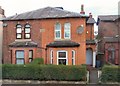
New Hall Cottages 1861
The date stone on this semi-detached property on Manchester Road, Audenshaw says "New Hall Cottages 1861".
Image: © Gerald England
Taken: 28 Nov 2012
0.08 miles
2
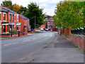
Ashton Hill Lane
Looking south, along Ashton Hill Lane, from the canal bridge.
Image: © David Dixon
Taken: 24 Oct 2016
0.09 miles
3
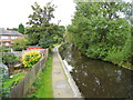
Ashton Canal, Droylsden
Back gardens from Ash Grove and Fairway.
Image: © John Topping
Taken: 27 Sep 2012
0.10 miles
4
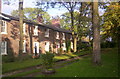
Moravian Settlement, Fairfield
Housing within the Moravian Settlement Conservation Area, Fairfield, Tameside
Image: © S Parish
Taken: 30 Oct 2006
0.10 miles
5
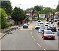
Manchester Road
The A635 at Fairfield.
Image: © Gerald England
Taken: 13 Jun 2015
0.10 miles
6
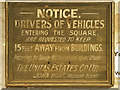
Old Notice, Fairfield Moravian Settlement
Notice, once displayed at the vehicular entrance to Fairfield Square, now displayed at the Fairfield Moravian Museum (housed in Image]).
Image: © David Dixon
Taken: 24 Oct 2016
0.10 miles
7
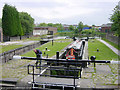
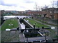
Fairfield Locks, Droylsden
At one time, the locks on the Ashton Canal were so busy that a pair of locks was necessary here. Above the locks, the canal turns to the right at the former junction with the Hollinwood Branch Canal.
Image: © Martin Clark
Taken: Unknown
0.10 miles
8
Robertsons Jam Factory - Ashton Hill
The home of Robertsons Jam in Droylsden
Image: © Gary Barber
Taken: 10 Apr 2005
0.10 miles
10
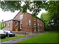
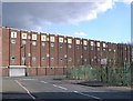
Fairfield, College
At the end of Sisters' Street in the Moravian Settlement; originally the Sisters' House, later girls' boarding school, then Theological College; now Sunday School and community centre. Listed by English Heritage: http://www.imagesofengland.org.uk/Details/Default.aspx?id=212726&mode=quick http://www.moravian.org.uk/index.php/uk-congregations-list-for-the-moravian-church/lancashire-district/fairfield
Image: © Mike Faherty
Taken: 25 May 2014
0.10 miles