IMAGES TAKEN NEAR TO
Meadowgate, MANCHESTER, M41 9LB
Introduction
This page details the photographs taken nearby to Meadowgate, M41 9LB by members of the Geograph project.
The Geograph project started in 2005 with the aim of publishing, organising and preserving representative images for every square kilometre of Great Britain, Ireland and the Isle of Man.

There are currently over 7.5m images from over14,400 individuals and you can help contribute to the project by visiting https://www.geograph.org.uk
Image Map
Images are licensed for reuse under creativecommons.org/licenses/by-sa/2.0
Notes
- Clicking on the map will re-center to the selected point.
- The higher the marker number, the further away the image location is from the centre of the postcode.
Image Listing (42 Images Found)
Images are licensed for reuse under creativecommons.org/licenses/by-sa/2.0
Image
Details
Distance
2
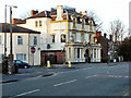
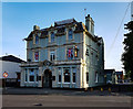
The Lord Nelson, Urmston
The Lord Nelson, a large public house at the corner of Station Road and Gloucester Road, Urmston.
Image: © David Dixon
Taken: 13 Mar 2011
0.07 miles
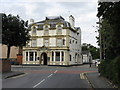
3
The Lord Nelson pub, Stretford Road, Urmston
Image: © JThomas
Taken: 9 Mar 2013
0.08 miles
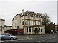
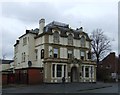
7
The Lord Nelson Pub, Urmston
This excellent Holts establishment offers extremely good value for money: on the date photographed, a pint of mixed (half bitter, half mild) cost £1.72. A highly recommended pub for the grown-up drinker.
Image: © Peter Whatley
Taken: 16 Sep 2009
0.09 miles
8
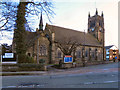
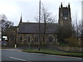
St Clement's Church, Urmston
In the mid 19th century, Urmston was a small rural community with a population of only 730; it was then part of Flixton parish. The expansion of industry and the coming of the railway caused the population to grow rapidly and it was recognised that Urmston needed a church of its own. The foundation stone was laid by the first Bishop of Manchester on 16 March 1867 and the building was consecrated just 9 months later.
http://www.stclementsonline.co.uk/about_history.asp - Church web site
Image: © David Dixon
Taken: 13 Mar 2011
0.09 miles
9
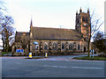
St Clement's Church, Urmston
In the mid 19th century, Urmston was a small rural community with a population of only 730; it was then part of Flixton parish. The expansion of industry and the coming of the railway caused the population to grow rapidly and it was recognised that Urmston needed a church of its own. The foundation stone was laid by the first Bishop of Manchester on 16 March 1867 and the building was consecrated just 9 months later.
http://www.stclementsonline.co.uk/about_history.asp - Church web site
Image: © David Dixon
Taken: 13 Mar 2011
0.09 miles