IMAGES TAKEN NEAR TO
Stretford Road, MANCHESTER, M41 9JY
Introduction
This page details the photographs taken nearby to Stretford Road, M41 9JY by members of the Geograph project.
The Geograph project started in 2005 with the aim of publishing, organising and preserving representative images for every square kilometre of Great Britain, Ireland and the Isle of Man.

There are currently over 7.5m images from over14,400 individuals and you can help contribute to the project by visiting https://www.geograph.org.uk
Image Map
Images are licensed for reuse under creativecommons.org/licenses/by-sa/2.0
Notes
- Clicking on the map will re-center to the selected point.
- The higher the marker number, the further away the image location is from the centre of the postcode.
Image Listing (67 Images Found)
Images are licensed for reuse under creativecommons.org/licenses/by-sa/2.0
Image
Details
Distance
1
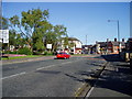
Stretford Road meets Church Road at Urmston.
The triangle of grass with its bedding plants maintained by Trafford Council is a welcoming view to the motorist when he arrives at Urmston town centre. The brick building on the corner was originally the local police station.
Image: © R Greenhalgh
Taken: 1 May 2007
0.06 miles
4
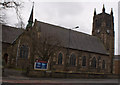
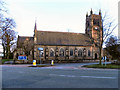
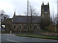
St Clement's Church, Urmston, Manchester
Image: © R Greenhalgh
Taken: 2 May 2007
0.06 miles
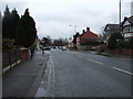
6
Junction of Stretford Road & Church Lane, Urmston
Image: © Anthony Parkes
Taken: 30 May 2010
0.07 miles
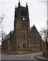
7
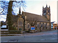
St Clement's Church, Urmston
In the mid 19th century, Urmston was a small rural community with a population of only 730; it was then part of Flixton parish. The expansion of industry and the coming of the railway caused the population to grow rapidly and it was recognised that Urmston needed a church of its own. The foundation stone was laid by the first Bishop of Manchester on 16 March 1867 and the building was consecrated just 9 months later.
http://www.stclementsonline.co.uk/about_history.asp - Church web site
Image: © David Dixon
Taken: 13 Mar 2011
0.07 miles
8
St Clement's Church, Urmston
In the mid 19th century, Urmston was a small rural community with a population of only 730; it was then part of Flixton parish. The expansion of industry and the coming of the railway caused the population to grow rapidly and it was recognised that Urmston needed a church of its own. The foundation stone was laid by the first Bishop of Manchester on 16 March 1867 and the building was consecrated just 9 months later.
http://www.stclementsonline.co.uk/about_history.asp - Church web site
Image: © David Dixon
Taken: 13 Mar 2011
0.07 miles
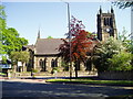
10
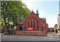
Urmston Unitarian Church
The church was built in 1900.
Image: © Gerald England
Taken: 26 Aug 2017
0.07 miles