IMAGES TAKEN NEAR TO
Jocelyn Street, MANCHESTER, M40 8PR
Introduction
This page details the photographs taken nearby to Jocelyn Street, M40 8PR by members of the Geograph project.
The Geograph project started in 2005 with the aim of publishing, organising and preserving representative images for every square kilometre of Great Britain, Ireland and the Isle of Man.

There are currently over 7.5m images from over14,400 individuals and you can help contribute to the project by visiting https://www.geograph.org.uk
Image Map
Images are licensed for reuse under creativecommons.org/licenses/by-sa/2.0
Notes
- Clicking on the map will re-center to the selected point.
- The higher the marker number, the further away the image location is from the centre of the postcode.
Image Listing (25 Images Found)
Images are licensed for reuse under creativecommons.org/licenses/by-sa/2.0
Image
Details
Distance
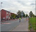
2
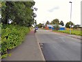
Upper Monsall Street
Bus stop by the entrance to the tram station.
Image: © Gerald England
Taken: 29 Jul 2017
0.05 miles
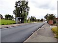
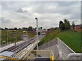
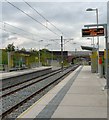
3
Monsall Manchester Metrolink tram stop
Looking east
Image: © Richard Cooke
Taken: 1 Nov 2013
0.06 miles
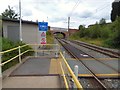
4
Monsall Tram Stop
An Oldham bound tram leaving Monsall Tram Stop on the first day of operation.
Image: © Gerald England
Taken: 13 Jun 2012
0.06 miles
5
Monsall Tram Stop
Monsall is a new build on the line of a former dismantled heavy rail line. Taken on the first day of operation of the Metrolink extension to Oldham. Looking towards Oldham from the steps down from Ruislip Avenue.
Image: © Gerald England
Taken: 13 Jun 2012
0.06 miles
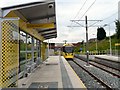
6
Monsall Tram Station
Monsall is a new build on the line of a former dismantled heavy rail line. Taken on the first day of operation of the Metrolink extension to Oldham.
Image: © Gerald England
Taken: 13 Jun 2012
0.06 miles
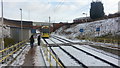
7
Tramway crossing at Monsall
Tramlines to Oldham and Rochdale at Monsall.
Image: © Gerald England
Taken: 29 Jul 2017
0.06 miles
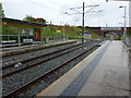
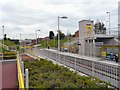
8
View east from Monsall Metrolink station
The tram line uses what was until the 1970s the primary railway route between Manchester Victoria and Rochdale. Jocelyn Street bridge's ironwork shows that the line was originally quadruple track. Additional supporting brickwork was added as part of the project to downgrade the Manchester-Oldham-Rochdale route from trains to trams.
Image: © Peter Whatley
Taken: 26 Jan 2013
0.06 miles
9
Monsall Tram Stop
Monsall is a new build on the line of a former dismantled heavy rail line. Taken on the first day of operation of the Metrolink extension to Oldham. As the electronic screen tells us, a tram is approaching. We are also informed that the next tram to St Werburgh's Road will be along in 14 minutes. And if the time is correct then comparing it to the information in the photograph's EXIF data the clock in my camera is 12 minutes fast (less an hour slow as it's still set to GMT).
Image: © Gerald England
Taken: 13 Jun 2012
0.07 miles
10
Monsall Street
Leading past Monsall tram stop.
Image: © Gerald England
Taken: 13 Jun 2012
0.07 miles