IMAGES TAKEN NEAR TO
Upper Monsall Street, MANCHESTER, M40 8NG
Introduction
This page details the photographs taken nearby to Upper Monsall Street, M40 8NG by members of the Geograph project.
The Geograph project started in 2005 with the aim of publishing, organising and preserving representative images for every square kilometre of Great Britain, Ireland and the Isle of Man.

There are currently over 7.5m images from over14,400 individuals and you can help contribute to the project by visiting https://www.geograph.org.uk
Image Map
Images are licensed for reuse under creativecommons.org/licenses/by-sa/2.0
Notes
- Clicking on the map will re-center to the selected point.
- The higher the marker number, the further away the image location is from the centre of the postcode.
Image Listing (27 Images Found)
Images are licensed for reuse under creativecommons.org/licenses/by-sa/2.0
Image
Details
Distance
1
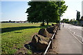
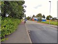
Upper Monsall Street
With defences to prevent unauthorised vehicles getting onto the grass.
Image: © Bill Boaden
Taken: 17 Jun 2010
0.04 miles
2
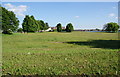
Open space in Monsall
I am pretty sure this was the former site of the Monsall Isolation Hospital.
Image: © Bill Boaden
Taken: 17 Jun 2010
0.07 miles
3
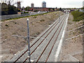
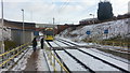
Metrolink Extension
Shown on the OS map as "dismantled railway"; new track has been laid on this old railway route, ready for the extension to the Metrolink tramway to run from Manchester to Oldham. This is looking towards Manchester, from Monsall Road. Sanderson Street is to the left of the cutting.
Image: © David Dixon
Taken: 13 Apr 2011
0.15 miles
4
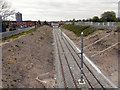
Metrolink Extension
Shown on the OS map as "dismantled railway", new track has been laid on this old railway route, ready for the extension to the Metrolink tramway to run from Manchester to Oldham. This is looking towards Manchester, from Monsall Road.
Image: © David Dixon
Taken: 13 Apr 2011
0.15 miles
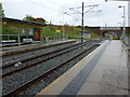
6
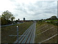
View east from Monsall Metrolink station
The tram line uses what was until the 1970s the primary railway route between Manchester Victoria and Rochdale. Jocelyn Street bridge's ironwork shows that the line was originally quadruple track. Additional supporting brickwork was added as part of the project to downgrade the Manchester-Oldham-Rochdale route from trains to trams.
Image: © Peter Whatley
Taken: 26 Jan 2013
0.15 miles
7
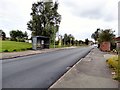
Upper Monsall Street
Bus stop by the entrance to the tram station.
Image: © Gerald England
Taken: 29 Jul 2017
0.16 miles
8
Metro line west of Monsall Road Bridge
Image: © Alexander P Kapp
Taken: 5 Oct 2011
0.16 miles
9
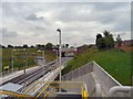
Monsall Tram Stop
Monsall is a new build on the line of a former dismantled heavy rail line. Taken on the first day of operation of the Metrolink extension to Oldham. Looking towards Oldham from the steps down from Ruislip Avenue.
Image: © Gerald England
Taken: 13 Jun 2012
0.16 miles
10
Monsall Manchester Metrolink tram stop
Looking east
Image: © Richard Cooke
Taken: 1 Nov 2013
0.16 miles