IMAGES TAKEN NEAR TO
Bishop Marshall Close, MANCHESTER, M40 8LX
Introduction
This page details the photographs taken nearby to Bishop Marshall Close, M40 8LX by members of the Geograph project.
The Geograph project started in 2005 with the aim of publishing, organising and preserving representative images for every square kilometre of Great Britain, Ireland and the Isle of Man.

There are currently over 7.5m images from over14,400 individuals and you can help contribute to the project by visiting https://www.geograph.org.uk
Image Map
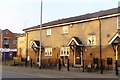
Images are licensed for reuse under creativecommons.org/licenses/by-sa/2.0
Notes
- Clicking on the map will re-center to the selected point.
- The higher the marker number, the further away the image location is from the centre of the postcode.
Image Listing (45 Images Found)
Images are licensed for reuse under creativecommons.org/licenses/by-sa/2.0
Image
Details
Distance
1
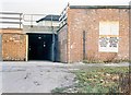
Miles Platting
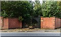
Gates accessing the old railway sidings.
Image: © Peter McDermott
Taken: 3 Oct 2017
0.12 miles
2
Queens Road, Monsall
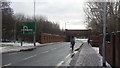
The view toward Miles Platting and the major junction at Oldham Road. The first railway bridge once carried goods lines from Manchester's Oldham Road goods depot. The main lines from Victoria station are beyond where the road dips. The brick wall on the right marks the one-time boundary of Brewery Sidings. Neither sidings, nor brewery have existed for many years.
Image: © Peter Whatley
Taken: 26 Jan 2013
0.14 miles
3
Churnet Street Retirement Scheme
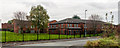
Disused retirement housing on Thornton Street North in Collyhurst.
Image: © Peter McDermott
Taken: 17 Oct 2014
0.14 miles
4
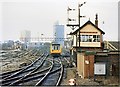
Miles Platting junction and signalbox 1989
A very busy manual signalbox at a key junction. An Oldham loop local train approaches. Separate, dedicated goods lines at one time existed from Collyhurst Street signalbox in the distance and continued towards Baguley Fold Junction on the Ashton line. Until the 1980s, the 1970s Arndale Tower and 1960s CIS Tower (Co-operative Insurance Society) were the only high-rise buildings in Manchester's city centre.
Image: © Peter Whatley
Taken: 11 Feb 1989
0.15 miles
6
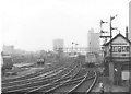
Miles Platting junction
The 17.37 Manchester Victoria-Leeds train approaches Miles Platting junction and its already aged signalbox. For about a decade, this was the only train using the old Lancashire & Yorkshire line across the Pennines which called at Miles Platting station. In 1977, Manchester's skyline had just two high-rise blocks, both of which are visible in the photograph. On the left, the much-derided Arndale tower from the early 1970s; to the right the CIS tower from a decade earlier. Compare with my photograph from the same spot a decade later!
Image: © Peter Whatley
Taken: Unknown
0.16 miles
7
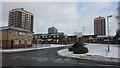
Collyhurst Village
The new 'Collyhurst Village' development.
Image: © Peter McDermott
Taken: 2 Sep 2024
0.17 miles
8
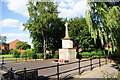
Collyhurst War Memorial
Erected primarily to honour the local dead of World War 1, and it's quite a long list.
Image: © Bill Boaden
Taken: 17 Jun 2010
0.17 miles
9
Miles Platting station entrance 1989
Grim entrance in a pretty grim neighbourhood. Most of the surrounding houses and industry had gone by 1989 and the station was slated for closure with minimal fuss. The poster on the left is promoting season tickets, not fare dodging!
Image: © Peter Whatley
Taken: 11 Feb 1989
0.17 miles