IMAGES TAKEN NEAR TO
Ashbury Place, MANCHESTER, M40 8DX
Introduction
This page details the photographs taken nearby to Ashbury Place, M40 8DX by members of the Geograph project.
The Geograph project started in 2005 with the aim of publishing, organising and preserving representative images for every square kilometre of Great Britain, Ireland and the Isle of Man.

There are currently over 7.5m images from over14,400 individuals and you can help contribute to the project by visiting https://www.geograph.org.uk
Image Map
Images are licensed for reuse under creativecommons.org/licenses/by-sa/2.0
Notes
- Clicking on the map will re-center to the selected point.
- The higher the marker number, the further away the image location is from the centre of the postcode.
Image Listing (64 Images Found)
Images are licensed for reuse under creativecommons.org/licenses/by-sa/2.0
Image
Details
Distance
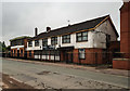
1
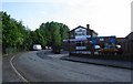
The Spanking Roger
It didn't appear in a great state of repair, but was reasonably busy. There are very few pubs left in this area.
Image: © Bill Boaden
Taken: 17 Jun 2010
0.08 miles
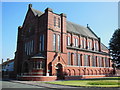
3
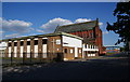
Corpus Christi Church, Miles Platting
On Varley Street, with the attached social club in front.
Image: © Bill Boaden
Taken: 17 Jun 2010
0.11 miles
4
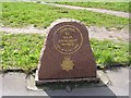
In memory of a fallen Policeman
Fatally injured when a stolen car rammed his police motorcycle.
Memorial – Oldham Road / Queens Road, Manchester
Image: © Keith Williamson
Taken: 13 Apr 2005
0.12 miles
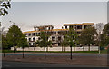
6
Miles Platting
Events venue at Miles Planning
Image: © Peter McDermott
Taken: 17 Jul 2018
0.12 miles
7
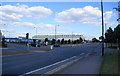
Hulme Hall Lane, Miles Platting
Part of the inner Manchester ringroad. Sportcity begins just the other side of the gasholder, and the land opposite is used for matchday parking.
Image: © Bill Boaden
Taken: 17 Jun 2010
0.13 miles
8
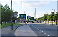
Hulme Hall Lane, Miles Platting
Approaching the junction with the A62 Oldham Road.
Image: © Bill Boaden
Taken: 17 Jun 2010
0.13 miles
9
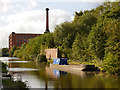
Rochdale Canal, Victoria Mill
A barge moored on the Rochdale Canal, between lock#77 and lock#78.
Victoria Mill can be seen behind the lock. The mill is a former textile mill. It was built in two phases in 1869 and 1873 to a design by the famous Bolton architect George Woodhouse. The mill was built for William Holland who moved his textile business to Miles Platting from his Adelphi Mill in Salford.
The mill’s distinctive chimney rises within a stair tower and at roof level there is a gallery of windows.
The Victoria Mill continued to operate until the 1960s but once it closed it fell into an almost derelict condition until it was restored in the 1990s. Today it is home to apartments, an adult learning centre, and NHS offices.
http://manchesterhistory.net/manchester/outside/victoriamill.html Manchester History Net
http://www.manchester2002-uk.com/history/victorian/mills.html Manchester2002
Image: © David Dixon
Taken: 29 Sep 2012
0.14 miles
10
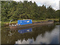
Rochdale Canal
Canal barge no 4000515 belonging to the Canal & River Trust, moored on the Rochdale Canal, to the east of Victoria Mill.
Image: © David Dixon
Taken: 29 Sep 2012
0.14 miles