IMAGES TAKEN NEAR TO
Collyhurst Road, MANCHESTER, M40 7RT
Introduction
This page details the photographs taken nearby to Collyhurst Road, M40 7RT by members of the Geograph project.
The Geograph project started in 2005 with the aim of publishing, organising and preserving representative images for every square kilometre of Great Britain, Ireland and the Isle of Man.

There are currently over 7.5m images from over14,400 individuals and you can help contribute to the project by visiting https://www.geograph.org.uk
Image Map
Images are licensed for reuse under creativecommons.org/licenses/by-sa/2.0
Notes
- Clicking on the map will re-center to the selected point.
- The higher the marker number, the further away the image location is from the centre of the postcode.
Image Listing (66 Images Found)
Images are licensed for reuse under creativecommons.org/licenses/by-sa/2.0
Image
Details
Distance
1
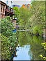
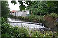
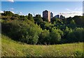
River Irk near Manchester
The River Irk rises to the east of Royton and flows westward through Chadderton, Middleton and Blackley before merging with the River Irwell in the centre of Manchester. This view is looking downstream towards Manchester city centre.
Image: © David Dixon
Taken: 1 May 2021
0.01 miles
3
River Irk, Manchester
The river is now very close to its confluence with the River Irwell in Manchester and disappears under buildings not far from here.
Image: © Keith Williamson
Taken: 7 Apr 2005
0.05 miles
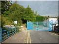
4
A weir on the River Irk
Taken from Collyhurst Road
Image: © Ian S
Taken: 3 Sep 2011
0.05 miles
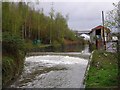
5
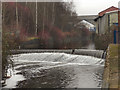
River Irk Weir
The River Irk, falling over the weir at Collyhurst Road, near Manchester city centre.
Image: © David Dixon
Taken: 15 Mar 2012
0.05 miles
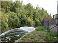
6
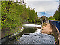
Weir on the River Irk
The River Irk rises to the east of Royton and flows westward through Chadderton, Middleton and Blackley before merging with the River Irwell in the centre of Manchester. This view is looking upstream over one of several small weirs in this area alongside Collyhurst Road.
Image: © David Dixon
Taken: 1 May 2021
0.05 miles
7
Weir on the River Irk
Looking upstream with Collyhurst Rd in the background.
Image: © Glyn Baker
Taken: 10 Sep 2021
0.05 miles
8
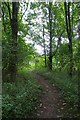
Irk Valley Park
This is the Irk Valley Path. Only a little further on it is blocked by a fallen tree. Judging by the undergrowth the blockage has been there for quite some time.
Image: © Glyn Baker
Taken: 10 Sep 2021
0.05 miles
9
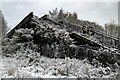
Ebenezer Works
Site of the Ebenzer Works in Collyhurst.
Image: © Peter McDermott
Taken: 3 Aug 2020
0.06 miles
10
Steps
Steps up to the footbridge crossing the old Redbank Sidings.
Depicted in Lowry's sketch: http://www.artnet.com/WebServices/images/ll00151lldpKbJFgPNECfDrCWvaHBOcGCtF/l.s.-lowry-steps.jpg
Image: © Peter McDermott
Taken: 29 Nov 2021
0.06 miles