IMAGES TAKEN NEAR TO
Joseph Dean Court, MANCHESTER, M40 5NU
Introduction
This page details the photographs taken nearby to Joseph Dean Court, M40 5NU by members of the Geograph project.
The Geograph project started in 2005 with the aim of publishing, organising and preserving representative images for every square kilometre of Great Britain, Ireland and the Isle of Man.

There are currently over 7.5m images from over14,400 individuals and you can help contribute to the project by visiting https://www.geograph.org.uk
Image Map
Images are licensed for reuse under creativecommons.org/licenses/by-sa/2.0
Notes
- Clicking on the map will re-center to the selected point.
- The higher the marker number, the further away the image location is from the centre of the postcode.
Image Listing (12 Images Found)
Images are licensed for reuse under creativecommons.org/licenses/by-sa/2.0
Image
Details
Distance
1

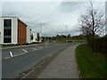
Entrance to Hanson Gardens - A New Housing Development
Image: © Anthony Parkes
Taken: 18 Jul 2012
0.05 miles

3
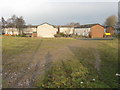
Houses off Thorp Road
A large estate, situated on the former Lancashire & Yorkshire railway's Lightbowne carriage sidings.
Image: © Peter Whatley
Taken: 19 Jan 2011
0.18 miles
4
Newton Heath - Thorp Road
The premises in the background are one of several business parks in the vicinity which have replaced failed and often derelict heavy industrial concerns.
Image: © Peter Whatley
Taken: 19 Jan 2011
0.20 miles
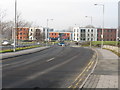
5

Central Park
Office buildings on Madison Place, part of the Central Park development.
Image: © Peter McDermott
Taken: 13 Nov 2015
0.20 miles
7
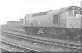
Newton Heath railway lands
From Newton Heath depot where a class 25 diesel locomotive has been stabled, Thorpes Bridge junction is visible in the distance. Alongside the junction is a residual fragment of the former Lancashire and Yorkshire Railway's carriage works.
Image: © Peter Whatley
Taken: Unknown
0.21 miles
8
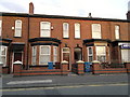
244 Lightbowne Road, Manchester
Terraced housing lines Lightbowne Road in the low profile Lightbowne area of North Manchester, England. I say low profile because it is not as well known as the neighbouring North Manchester districts of Moston, Newton Heath and Harpurhey. This particular photograph is centred on number 244 Lightbowne Road - a red-brick terraced house that is typical of both Manchester and Greater Manchester as a whole.
Image: © Steven Haslington
Taken: 3 Aug 2011
0.22 miles
9

Oldham loop line from Dean Lane
A view of the former Oldham railway line, looking towards Manchester. Newton Heath rolling stock depot is on the right. The rather wet trackbed on the left will provide the route of a tram operation to Oldham from 2012, if the plans are on schedule.
Image: © Peter Whatley
Taken: 19 Jan 2011
0.23 miles