IMAGES TAKEN NEAR TO
Oldham Road, MANCHESTER, M40 5AP
Introduction
This page details the photographs taken nearby to Oldham Road, M40 5AP by members of the Geograph project.
The Geograph project started in 2005 with the aim of publishing, organising and preserving representative images for every square kilometre of Great Britain, Ireland and the Isle of Man.

There are currently over 7.5m images from over14,400 individuals and you can help contribute to the project by visiting https://www.geograph.org.uk
Image Map
Images are licensed for reuse under creativecommons.org/licenses/by-sa/2.0
Notes
- Clicking on the map will re-center to the selected point.
- The higher the marker number, the further away the image location is from the centre of the postcode.
Image Listing (79 Images Found)
Images are licensed for reuse under creativecommons.org/licenses/by-sa/2.0
Image
Details
Distance
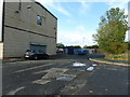
4

Side street off Bower St., between Miles Platting and Newton Heath, Manchester
A typically grim North Country scene. (Evidently some Worker had a posh car - or was it a visiting Doctor; it was not mine).
Image: © Ben Brooksbank
Taken: 18 Apr 1962
0.10 miles

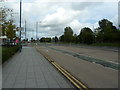
6

The Gateway
View from the southbound side of Central Park Metrolink stop. The bridge over The Gateway carries the mainline railway to Rochdale.
Image: © Gerald England
Taken: 10 Sep 2016
0.12 miles
7

Central Park Tram Station
Metrolink tram 3021, a Bombardier M5000, leaves the Central Park tram station on its way from Oldham Mumps towards Manchester Victoria (and then on to St Werburgh's Road).
Image: © David Dixon
Taken: 22 Jul 2012
0.12 miles
8
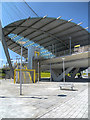
Central Park Metrolink Station
Central Park Station, part of the recently (June 2012) opened Metrolink “phase 3A” expansion to Oldham, is certainly the most impressive tram stop on the network to date, featuring a striking curved copper and glass canopy suspended by a cable-tensioned steel structure. The station serves The Central Park Urban Regeneration Area in north-east Manchester. It forms part of The Gateway, a £36.5 million transport interchange which will include local bus services as well as the Metrolink tram stop (http://www.manchester.gov.uk/site/scripts/news_article.php?newsID=1582 Manchester City Council).
http://www.metrolink.co.uk/stationinfo/results/index.asp Metrolink
http://en.wikipedia.org/wiki/Central_Park_Metrolink_station Wikipedia
Image: © David Dixon
Taken: 22 Jul 2012
0.12 miles
9
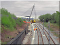
New Tramway Under Construction
Shown on the OS map as "dismantled railway", new track has been laid in this old railway cutting, ready for the extension to the Metrolink tramway to run from Manchester to Oldham and Rochdale. This is looking towards Oldham, from Monsall Road. The spectacular structure ahead is part of the newly constructed Central Park tram station (http://en.wikipedia.org/wiki/Central_Park_Metrolink_station ).
Image: © David Dixon
Taken: 13 Apr 2011
0.13 miles
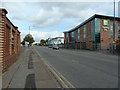
10

Approach to Central Park Metrolink Station
Along the very broad pedestrian access of The Gateway
Image: © Kevin Waterhouse
Taken: 3 Mar 2023
0.13 miles