IMAGES TAKEN NEAR TO
Underhill Walk, MANCHESTER, M40 2QW
Introduction
This page details the photographs taken nearby to Underhill Walk, M40 2QW by members of the Geograph project.
The Geograph project started in 2005 with the aim of publishing, organising and preserving representative images for every square kilometre of Great Britain, Ireland and the Isle of Man.

There are currently over 7.5m images from over14,400 individuals and you can help contribute to the project by visiting https://www.geograph.org.uk
Image Map
Images are licensed for reuse under creativecommons.org/licenses/by-sa/2.0
Notes
- Clicking on the map will re-center to the selected point.
- The higher the marker number, the further away the image location is from the centre of the postcode.
Image Listing (24 Images Found)
Images are licensed for reuse under creativecommons.org/licenses/by-sa/2.0
Image
Details
Distance
1
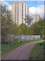
Newton Heath Flats From Clayton Vale.
The northern edge of Clayton Vale Nature Reserve is overlooked by these blocks of flats.
Image: © David Dixon
Taken: 1 May 2010
0.04 miles
2
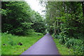
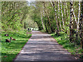
A path in Clayton Vale
The vale was caused by the River Medlock, but so far on this path you haven't seen the river yet.
Image: © Bill Boaden
Taken: 8 Jun 2010
0.14 miles
3
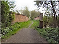
Clayton Vale
One of the main paths through the Clayton Vale Nature Reserve.
Image: © David Dixon
Taken: 1 May 2010
0.14 miles
4
Disused Railway, Clayton Vale
The course of the railway over this viaduct now forms part of the network of paths in the Clayton Vale Nature Reserve (see Image])
Image: © David Dixon
Taken: 1 May 2010
0.15 miles
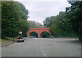
5
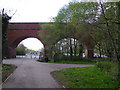
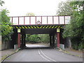
Clayton Vale Viaduct
The viaduct at the western end of the Clayton Vale Nature Reserve at the Bridge Park Road entrance. The railway which once passed over the valley at this point is disused and the viaduct now carries a footpath. (Image])
Image: © David Dixon
Taken: 1 May 2010
0.15 miles
6
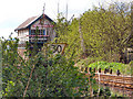
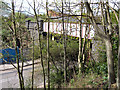
Signal Box: Baguley Fold Junction
Thick briar and hawthorn hedges lining the railway at this point make it easy to miss spotting this signal box.
Image: © David Dixon
Taken: 1 May 2010
0.15 miles
7
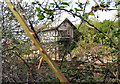
Baguley Fold Junction Signal Box
Thick briar and hawthorn hedges line the railway at this point making it easy to miss spotting this signal box.
Image: © David Dixon
Taken: 1 May 2010
0.15 miles
8
Riverpark Road at Ten Acres Lane junction
Image: © Colin Pyle
Taken: 24 Sep 2021
0.15 miles