1
Money for nothing
A contemporary Bradford & Bingley advert. Surely not that financial institution's mission statement. This advert was seen the day after we heard the country was heading towards an economic recession. Ironic. Looking southwest down Hollinwood Avenue (A6104) near Moston railway station.
Image: © michael ely
Taken: 9 Jul 2008
0.06 miles
2
Disused Commercial Premises, Victoria Avenue
Image: © Peter Whatley
Taken: 20 Jan 2010
0.08 miles
3
Moston railway station, Greater Manchester
Opened in 1879 by the Lancashire & Yorkshire Railway on its line from Manchester Victoria to Rochdale. The entrance on Hollinwood Road is not particularly well signposted. The entrance to the Rochdale-bound platform is across the road on the right. The entrance to the Manchester-bound platform has a small National Rail (former BR) 'Double Arrows' symbol in the middle distance - easily missed.
Image: © Nigel Thompson
Taken: 11 Mar 2019
0.08 miles
4
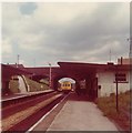
Moston station 1977
Moston station from the footpath to the east of the railway cutting. Beyond the station is a petrol station selling National Benzole fuel and a private preparatory school. Rapid vegetation growth since the 1980s make this view unrepeatable, though the station is still in use, minus both buildings shown.
Image: © Peter Whatley
Taken: Unknown
0.11 miles
5
Moston station, looking north in 1972
Moston station with its full 1930s station buildings in June 1972. The signal shown indicates that Moston Junction signalbox was still in use: it was destroyed by a suspicious fire in November 1973 and the signal replaced by a more modern, colour-light item, controlled from Vitriol Works signalbox, a short distance to the north of Moston station.
Image: © Peter Whatley
Taken: 3 Jun 1972
0.11 miles
6
Moston railway station, Greater Manchester
Opened in 1879 by the Lancashire & Yorkshire Railway on its line from Manchester Victoria to Rochdale.
View north towards Middleton Junction and Rochdale, showing the replacement shelters installed in 2017.
Image: © Nigel Thompson
Taken: 11 Mar 2019
0.11 miles
7
Manchester & Leeds Railway North Of Moston Station
Part of the first Trans-Pennine railway immediately north of Moston station. The next bridge carries the M60 motorway. Between 1955-1986 the view ahead would have been dominated by Chadderton B electricity generating station and its attendant cooling towers (see http://www.geograph.org.uk/photo/810586 for a view from further south).
Image: © Peter Whatley
Taken: 20 Jan 2010
0.12 miles
8
Path approaching Hollinwood Avenue
This surfaced path links Nuthurst Road with Hollinwood Avenue and runs parallel with the railway in a cutting at Moston
Image: © Kevin Waterhouse
Taken: 9 Apr 2023
0.12 miles
9
Victoria Avenue, New Moston
Image: © Peter Whatley
Taken: 20 Jan 2010
0.13 miles
10
Platform art at Moston railway station
Image: © Raymond Knapman
Taken: 26 Jan 2012
0.13 miles


