IMAGES TAKEN NEAR TO
Kirkstone Road, MANCHESTER, M40 0HE
Introduction
This page details the photographs taken nearby to Kirkstone Road, M40 0HE by members of the Geograph project.
The Geograph project started in 2005 with the aim of publishing, organising and preserving representative images for every square kilometre of Great Britain, Ireland and the Isle of Man.

There are currently over 7.5m images from over14,400 individuals and you can help contribute to the project by visiting https://www.geograph.org.uk
Image Map
Images are licensed for reuse under creativecommons.org/licenses/by-sa/2.0
Notes
- Clicking on the map will re-center to the selected point.
- The higher the marker number, the further away the image location is from the centre of the postcode.
Image Listing (27 Images Found)
Images are licensed for reuse under creativecommons.org/licenses/by-sa/2.0
Image
Details
Distance
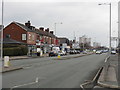
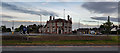
3
Disused Commercial Premises, Victoria Avenue
Image: © Peter Whatley
Taken: 20 Jan 2010
0.13 miles
4
The Gardeners Arms, Lightbowne Road, Moston
Image: © Alexander P Kapp
Taken: 5 Oct 2011
0.13 miles
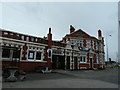
6
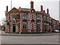
The Gardeners Arms
Public house at the corner of Moston Lane and Lightbowne Road at the Greengate Roundabout.
Image: © David Dixon
Taken: 9 Apr 2010
0.14 miles
7
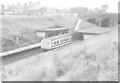
Moston station 1977
Moston station from the footpath to the east of the railway cutting. Beyond the station is a petrol station selling National Benzole fuel and a private preparatory school. Rapid vegetation growth since the 1980s make this view unrepeatable, though the station is still in use, minus both buildings shown.
Image: © Peter Whatley
Taken: Unknown
0.15 miles
8
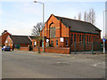
The Methodist Church, Chain Bar
Methodist Church on the corner of Nina Drive with Moston Lane.
Image: © David Dixon
Taken: 9 Apr 2010
0.15 miles
9
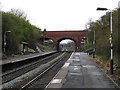
Moston station, looking north
View north from Moston station's Manchester-bound platform, taken around 15.00 on a very wet April 9th, 2008. First bridge is Hollinwood Avenue (A6104); the second is the M60 motorway. Pylon visible through the bridge effectively marks the site of the former Chadderton electricity generating station, now Broadway business park.
Image: © Peter Whatley
Taken: 9 Apr 2008
0.16 miles
10
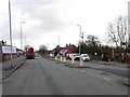
Moston railway station, Greater Manchester
Opened in 1879 by the Lancashire & Yorkshire Railway on its line from Manchester Victoria to Rochdale. The entrance on Hollinwood Road is not particularly well signposted. The entrance to the Rochdale-bound platform is across the road on the right. The entrance to the Manchester-bound platform has a small National Rail (former BR) 'Double Arrows' symbol in the middle distance - easily missed.
Image: © Nigel Thompson
Taken: 11 Mar 2019
0.17 miles