IMAGES TAKEN NEAR TO
Kays Gardens, SALFORD, M3 6BW
Introduction
This page details the photographs taken nearby to Kays Gardens, M3 6BW by members of the Geograph project.
The Geograph project started in 2005 with the aim of publishing, organising and preserving representative images for every square kilometre of Great Britain, Ireland and the Isle of Man.

There are currently over 7.5m images from over14,400 individuals and you can help contribute to the project by visiting https://www.geograph.org.uk
Image Map
Images are licensed for reuse under creativecommons.org/licenses/by-sa/2.0
Notes
- Clicking on the map will re-center to the selected point.
- The higher the marker number, the further away the image location is from the centre of the postcode.
Image Listing (292 Images Found)
Images are licensed for reuse under creativecommons.org/licenses/by-sa/2.0
Image
Details
Distance
1
Salford Town Hall – detail
See https://www.geograph.org.uk/photo/7873634 for location.
Image: © Alan Murray-Rust
Taken: 23 Aug 2024
0.07 miles
2
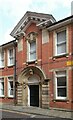
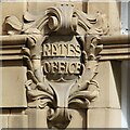
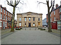
Salford Town Hall
Entrance to the former Rates Office on Ford Street. This wing is an addition of c.1900 to the original early 19th century building https://www.geograph.org.uk/photo/7873658 . Listed Grade II.
Image: © Alan Murray-Rust
Taken: 23 Aug 2024
0.07 miles
3
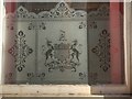
Integrity and Industry
The windows of the town hall extension carry the city's coat of arms and the motto "INTEGRITY & INDUSTRY". It appears as a mirror image in this photograph because we are looking from the outside.
Image: © David Dixon
Taken: 11 Mar 2014
0.08 miles
4
Salford Town Hall
The Town Hall building in Salford.
Image: © Peter McDermott
Taken: 15 Jun 2013
0.08 miles
7

Water Offices, Salford Town Hall Extension
Detail over one of the courtyard doorways of the town hall extension.
Image: © David Dixon
Taken: 11 Mar 2014
0.08 miles
8
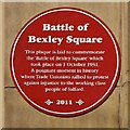
The Battle of Bexley Square
Red plaque attached to Image] in 2011.
This plaque is laid to commemorate
the 'Battle of Bexley Square' which
took place on 1 October 1931.
A poignant moment in history
where Trade Unionists rallied to protest
against injustice to the working class
people of Salford
Image: © David Dixon
Taken: 11 Mar 2014
0.08 miles
9
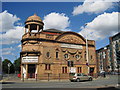
Salford Cinema
This building on the corner of Chapel Street and Trinity Way has an unusual history. It was originally built as a Scottish Presbyterian Church in 1846, complete with tall spire. The present frontage was then added in 1912 and it was opened as the Salford Cinema, (one of the first in Salford and Manchester) which then changed in 1938 to the Rex Cinema, surviving until 1958 before becoming a bingo hall between 1967 and 1985. Now the wheel has come full circle, and the building is once again a House of God as The New Harvest Christian Fellowship Church.
Image: © Sue Adair
Taken: 25 Jul 2009
0.08 miles
10
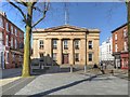
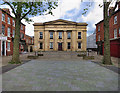
Former Salford Town Hall, Bexley Square
The old Salford Town Hall, which was built between 1825 and 1827, sits at the far end of Bexley Square, just off Chapel Street. It is a Grade II listed building (English Heritage ID:471500 http://www.britishlistedbuildings.co.uk/en-471500-town-hall- British Listed Buildings).
Detail from an 1849 map http://manchesterhistory.net/manchester/outside/salfordThall.html shows that the building was not only home to the business of the Town Hall but also included a police station, fire station and a court house. Today the business of the City of Salford is conducted at Image
The tree-lined square gained notoriety in 1931 when it was the scene of the infamous ‘Battle of Bexley Square’. This was the fight against the government-enforced means test and poverty in Salford, which went on to feature in Walter Greenwood’s play ‘Love on The Dole’ (Image]).
http://manchesterhistory.net/manchester/outside/salfordThall.html Manchester History Net
http://www.visitsalford.info/documents/chapelstreettrail.pdf Chapel Street Heritage Trail
Image: © David Dixon
Taken: 11 Mar 2014
0.09 miles