IMAGES TAKEN NEAR TO
Waterway Close, MANCHESTER, M35 0TS
Introduction
This page details the photographs taken nearby to Waterway Close, M35 0TS by members of the Geograph project.
The Geograph project started in 2005 with the aim of publishing, organising and preserving representative images for every square kilometre of Great Britain, Ireland and the Isle of Man.

There are currently over 7.5m images from over14,400 individuals and you can help contribute to the project by visiting https://www.geograph.org.uk
Image Map
Images are licensed for reuse under creativecommons.org/licenses/by-sa/2.0
Notes
- Clicking on the map will re-center to the selected point.
- The higher the marker number, the further away the image location is from the centre of the postcode.
Image Listing (72 Images Found)
Images are licensed for reuse under creativecommons.org/licenses/by-sa/2.0
Image
Details
Distance
1
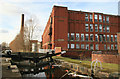
Dirty lock, Rochdale Canal
This is lock No. 66 and contains a lot of floating junk. Marlborough No. 1 Mill is in the background in the next square west.
Image: © Chris Allen
Taken: 13 Feb 2010
0.05 miles
4
Lock 66, Rochdale Canal
Between Failsworth and Newton Heath.
Image: © michael ely
Taken: 16 May 2014
0.06 miles
5

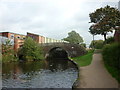
Tannersfield Canal Footbridge
On the Rochdale Canal, this is bridge No.79A
Image: © Kevin Waterhouse
Taken: 7 Feb 2023
0.06 miles
6
Bridge #79a, Ridgefield Street, Rochdale Canal
Image: © Ian S
Taken: 4 Oct 2011
0.06 miles
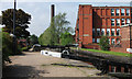
7
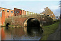
Rochdale Canal, Bridge 79a and Lock No. 66
On the canal through Failsworth.
Image: © Chris Allen
Taken: 13 Feb 2010
0.06 miles
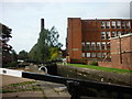
8
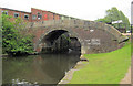
Bridge 79a
Rochdale Canal below Tannersfield Highest Lock 66
Image: © Mike Todd
Taken: 13 Jun 2011
0.07 miles
9

Footbridge by Lock 66
Looking towards Ridgefield St.
Image: © Glyn Baker
Taken: 24 Sep 2016
0.07 miles
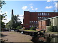
10

Marlborough No.1 Mill, Failsworth
This is a former cotton spinning mill that was built in 1905 to a design by PS Stott. The spindleage in 1915 was 114,456 and power was provided by a George Saxon inverted vertical triple expansion steam engine of 1700 horsepower. Production ceased in 1955 and it was then used as a distribution warehouse. The adjoining No. 2 Mill has been replaced by a Morrisons supermarket.
Image: © Chris Allen
Taken: 13 Feb 2010
0.08 miles