IMAGES TAKEN NEAR TO
Catalan Square, MANCHESTER, M3 4RU
Introduction
This page details the photographs taken nearby to Catalan Square, M3 4RU by members of the Geograph project.
The Geograph project started in 2005 with the aim of publishing, organising and preserving representative images for every square kilometre of Great Britain, Ireland and the Isle of Man.

There are currently over 7.5m images from over14,400 individuals and you can help contribute to the project by visiting https://www.geograph.org.uk
Image Map
Images are licensed for reuse under creativecommons.org/licenses/by-sa/2.0
Notes
- Clicking on the map will re-center to the selected point.
- The higher the marker number, the further away the image location is from the centre of the postcode.
Image Listing (1322 Images Found)
Images are licensed for reuse under creativecommons.org/licenses/by-sa/2.0
Image
Details
Distance
1
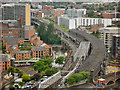
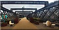
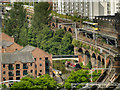
Castlefield Viaducts
The nineteenth century railway viaducts at Castlefield. Also in the photograph are the Bridgewater Canal, Castlefield Basin and the many modern apartment blocks that have appeared as the area has been "regenerated". This view is from the 14th floor of the Beetham Tower (Hilton Hotel Image]).
Image: © David Dixon
Taken: 2 Jul 2012
0.01 miles
2
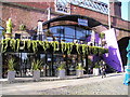
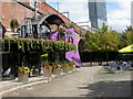
The Barca Bar, Castlefield
Arches 8 & 9, Catalan Square, Castlefield, MANCHESTER M3 4RU on the Bridgewater Canal
Image: © canalandriversidepubs co uk
Taken: 7 Apr 2010
0.01 miles
3
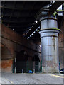
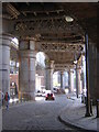
Railway bridges at Castlefield
The upper bridge is a very substantial structure, held up by several of these large pillars. Duke Street is in the foreground.
Image: © Thomas Nugent
Taken: 28 Feb 2011
0.01 miles
4
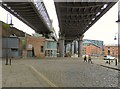
Castlefield Viaduct
The Grade II listed https://historicengland.org.uk/listing/the-list/list-entry/1292315 viaduct carried the lines from the former Central Station, dividing into two over Castlefield and rejoining west of the River Medlock. The left hand portion now carries the Metrolink line out of Deansgate/Castlefield. The right hand portion is still unused. A separate viaduct that carries the railway line from Deansgate to Salford Crescent can be seen on the left.
Image: © Gerald England
Taken: 19 Jun 2018
0.01 miles
5
National Trust Castlefield Viaduct Urban Park - Manchester
Image: © Anthony Parkes
Taken: 2 Mar 2023
0.01 miles
6
Castlefields, Manchester: Duke Street, under the railway viaducts
At the bottom of the hill, a footbridge marks part of the complex of canal arms and basins that twist either side of the main line of canal, fanning out from a point where the Rochdale Canal descends into the Bridgewater and the course of the River Medlock crosses.
Image: © Christopher Hilton
Taken: 2 Jun 2016
0.01 miles
7
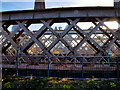
Metrolink Viaduct at Castlefield (view from the 'Sky Park')
Three viaducts, built by competing railway companies during the nineteenth century, run through Castlefield into Manchester city centre. The middle one has been disused since it was closed in 1969whilst the one immediately to the south of it has been converted for use by the Metrolink tramway. This view is from the central viaduct, looking towards the one now used by Metrolink.
Image: © David Dixon
Taken: 23 Feb 2023
0.01 miles
8
Castlefield, Catalan Square
The space around the junction of Rochdale and Bridgewater Canals has become a magnet for visitors, assisted by striking buildings such as Bar Ça attached to a railway viaduct.
Image: © Mike Faherty
Taken: 31 Aug 2009
0.02 miles
9
Castlefield
The Bridgewater Canal and Castlefield Viaducts.
Image: © David Dixon
Taken: 3 Jul 2012
0.02 miles
10
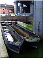
Old barges at Castlefield basin
Manchester Ship Canal Mud Boats No 6 and 7 tied up and gathering water at the basin. These were presumably used during the dredging process to collect mud for disposal elsewhere.
Image: © Thomas Nugent
Taken: 28 Feb 2011
0.02 miles