IMAGES TAKEN NEAR TO
Deansgate, MANCHESTER, M3 4LQ
Introduction
This page details the photographs taken nearby to Deansgate, M3 4LQ by members of the Geograph project.
The Geograph project started in 2005 with the aim of publishing, organising and preserving representative images for every square kilometre of Great Britain, Ireland and the Isle of Man.

There are currently over 7.5m images from over14,400 individuals and you can help contribute to the project by visiting https://www.geograph.org.uk
Image Map (1718 Images)
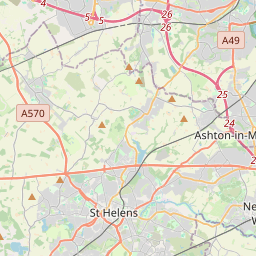

Leaflet Map data © OpenStreetMap
Images are licensed for reuse under creativecommons.org/licenses/by-sa/2.0
Notes
- Clicking on the map will re-center to the selected point.
- The higher the marker number, the further away the image location is from the centre of the postcode.
Image Listing (1718 Images Found)
Images are licensed for reuse under creativecommons.org/licenses/by-sa/2.0
Image
Details
Distance
1
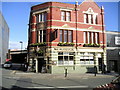
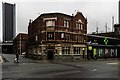
The Deansgate Pub, Manchester
Deansgate, MANCHESTER M3 4LQ close to The Bridgewater Canal
Image: © canalandriversidepubs co uk
Taken: 7 Apr 2010
0.00 miles
2
Manchester Central
The exhibition centre at Manchester Central with the Beetham Tower behind it; the latter already dwarfed by the to-be-completed Deansgate Square development to the left of shot.
Image: © Carroll Pierce
Taken: 24 Dec 2018
0.00 miles
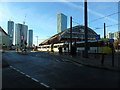
3
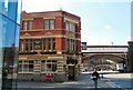
The Deansgate
The Deansgate public house in Manchester.
Image: © Peter McDermott
Taken: 27 Dec 2019
0.00 miles
4
Beetham Tower from Gower Hey
The Beetham Tower as viewed from Gower Hey Image
Image: © Gerald England
Taken: 14 Jun 2009
0.00 miles
5
The Deansgate
At the corner of Trafford Street. The first bridge carries the Metrolink tramway whilst the one further in the background carries the main railway line. On the left is a small corner of the Hilton Hotel Image
Its sign Image depicts Manchester's Victorian trams.
Image: © Gerald England
Taken: 22 Apr 2010
0.00 miles
7
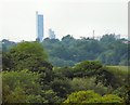
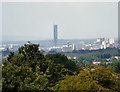
Manchester from near Woodley
A zoomed view of the Beetham Tower and the Manchester skyline with cranes emphasising the construction taken place in the city. Taken from meadowland Image beside the Peak Forest Canal near Woodley.
Image: © Gerald England
Taken: 1 Jun 2014
0.01 miles
8
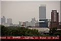
A long way from the Cricket
Manchester city skyline, as seen (north eastwards) from Old Trafford cricket ground. The very tall building is the Hilton Hotel at the bottom of Deansgate. (Unfortunately, whilst we can see the Hilton, they cannot see the Cricket.)
Image: © Anthony O'Neil
Taken: 8 Aug 2014
0.01 miles
9
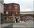
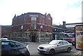
321 Deansgate
The Crown Inn at 321 Deansgate is first recorded in 1876 http://pubhistory.co.uk/Lancashire/ManchesterC/CrownInnDeansgate.shtml
It was a Walker & Homfrays pub in the early 20th century until Wilsons bought out the smaller Salford brewery in 1949. http://pubs-of-manchester.blogspot.co.uk/2010/02/22-deansgate-deansgate-formerly-crown.html
It was a Wilsons house in the 1970s http://www.images.manchester.gov.uk/web/objects/common/webmedia.php?irn=74415 through to the 1990s http://www.images.manchester.gov.uk/web/objects/common/webmedia.php?irn=1183
In the 21st century it became Galvin's Irish Bar until 2006.
It reopened later as The Deansgate. https://manchesterhistory.net/manchester/tours/tour7/area7page2.html
but has now become the 3twentyone Smokehouse.
It stands on the corner of Trafford Street opposite the Beetham Tower Image
The first bridge beyond carries the Metrolink tramway whilst the one further in the background carries the main railway line.
Image: © Gerald England
Taken: 30 Jan 2014
0.01 miles
10
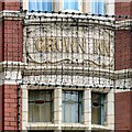
Crown Inn
The original name of the former Deansgate Image inscribed above the entrance of what is now a smokehouse Image
Image: © Gerald England
Taken: 30 Jan 2014
0.01 miles