IMAGES TAKEN NEAR TO
Manor Road, MANCHESTER, M34 7SL
Introduction
This page details the photographs taken nearby to Manor Road, M34 7SL by members of the Geograph project.
The Geograph project started in 2005 with the aim of publishing, organising and preserving representative images for every square kilometre of Great Britain, Ireland and the Isle of Man.

There are currently over 7.5m images from over14,400 individuals and you can help contribute to the project by visiting https://www.geograph.org.uk
Image Map
Images are licensed for reuse under creativecommons.org/licenses/by-sa/2.0
Notes
- Clicking on the map will re-center to the selected point.
- The higher the marker number, the further away the image location is from the centre of the postcode.
Image Listing (64 Images Found)
Images are licensed for reuse under creativecommons.org/licenses/by-sa/2.0
Image
Details
Distance
1
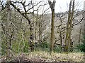
Haughton Dale
From within Gower Hey Wood, with the trees still fairly bare, there is a glimpse of the River Tame flowing through Haughton Dale.
Image: © Gerald England
Taken: 21 Apr 2013
0.15 miles
2
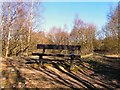
Haughton Dale Bench
A bench in Haughton Dale near the Peak Forest Canal overlooking the path to Gibraltar Row Image
Image: © Gerald England
Taken: 7 Mar 2010
0.15 miles
3
Haugton Dale Nature Reserve
Path leading to Gibraltar Lane (SJ9393) from the Peak Forest Canal, through Haughton Dale Nature Reserve.
Image: © John Topping
Taken: 20 Feb 2013
0.16 miles
4
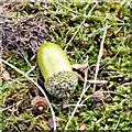
Fallen Acorn
Image: © Gerald England
Taken: 30 Sep 2016
0.17 miles
5
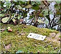
Fishing Peg #238
Alongside the Peak Forest Canal Image is a fishing peg numbered 238. Behind is a sign that says No Fishing Image It is surround by fallen acorns Image
Image: © Gerald England
Taken: 30 Sep 2016
0.17 miles
6
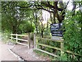
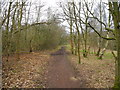
Path to Haughton Dale
Leading off the towpath of the Peak Forest Canal Image is a footpath through the woods leading to Haughton Dale Local Nature Reserve. A sign warns NO MOTORCYCLING, NO SHOOTING, NO FISHING. The latter I presume does not apply to the canal as there is a fishing peg number opposite Image
Image: © Gerald England
Taken: 30 Sep 2016
0.17 miles
7
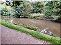
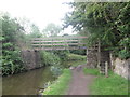
Peak Forest Canal
Behind the photographer is a footpath leading to Haughton Dale nature reserve Image and a sign saying No Fishing. I presume that applies to the nature reserve not the canal as in front of the photographer is a fishing peg number Image
Image: © Gerald England
Taken: 30 Sep 2016
0.17 miles
8

Footpath to Gibraltar Row
A footpath leading from the Peak Forest Canal south of Captain Clark's Bridge towards Gibraltar Row and Haughton Vale.
For more information on Gibraltar Row see http://oldhyde.blogspot.com/2007/09/gibralter-mill-gibralter-row.html
Image: © Gerald England
Taken: 9 Sep 2007
0.17 miles
9
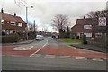
Manor Road
Leading to the St John Fisher RC Primary School.
Image: © Gerald England
Taken: 15 Feb 2013
0.17 miles