IMAGES TAKEN NEAR TO
Truro Walk, MANCHESTER, M34 7JW
Introduction
This page details the photographs taken nearby to Truro Walk, M34 7JW by members of the Geograph project.
The Geograph project started in 2005 with the aim of publishing, organising and preserving representative images for every square kilometre of Great Britain, Ireland and the Isle of Man.

There are currently over 7.5m images from over14,400 individuals and you can help contribute to the project by visiting https://www.geograph.org.uk
Image Map
Images are licensed for reuse under creativecommons.org/licenses/by-sa/2.0
Notes
- Clicking on the map will re-center to the selected point.
- The higher the marker number, the further away the image location is from the centre of the postcode.
Image Listing (25 Images Found)
Images are licensed for reuse under creativecommons.org/licenses/by-sa/2.0
Image
Details
Distance
1
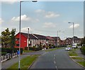
Lancaster Road
Passing Denbigh Road.
Image: © Gerald England
Taken: 27 Jun 2011
0.06 miles
2
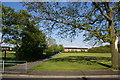
Path between estates
This path links the older Corrie estate on Cemetery Road and westwards with the visible houses which form part of the former Manchester overspill Haughton Green Estate. To the left is the bottom of the playing field of Corrie Primary School.
Image: © Bill Boaden
Taken: 17 May 2010
0.14 miles
3
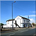
Cock Hotel
The Cock Hotel on Two Trees Lane, Haughton Green, predates the Victoria Works Image next door and seems to have had a makeover since David Dixon photographed in 2011 Image and Anthony Parkes in 2012 Image
Image
Image: © Gerald England
Taken: 11 May 2015
0.17 miles
5
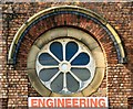
Victoria Works: Rose Window
Rose window of the former Two Trees Lane United Methodist Free Church Image
Image: © Gerald England
Taken: 11 May 2015
0.17 miles
6
Victoria Works
Two Trees Lane United Methodist Free Church was built next door to the Cock Hotel, which predates it. Architecturally, it has a strong resemblance to the Wesleyan Sunday School Image on the opposite side of Two Trees Lane (now much altered), which was built in 1877, and it is possible that the same architect designed both buildings.
The date of closure of the church is unknown but trade directories suggest that it was prior to 1903. It was by then known as Victoria Works and was occupied by the engineering firm of John Brown (Denton) Ltd which was founded in 1880 and specialised in the manufacture of hat wire and spokes for the cycle and motor trades.
Additional information can be found at http://www.pittdixon.go-plus.net/denton/john-brown.htm
The current occupiers are Moorside Manufacturing, a family owned and run precision engineering company formed in 1991. http://moorsideengineering.com/
Image: © Gerald England
Taken: 11 May 2015
0.17 miles
8
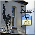
The Cock Hotel: New signs
Signs on the Cock Hotel Image
Image: © Gerald England
Taken: 11 May 2015
0.18 miles
9
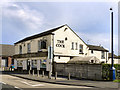
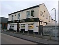
The Cock
The Cock Hotel on Two Trees Lane, Haughton Green
Image: © David Dixon
Taken: 4 Jun 2011
0.18 miles
10
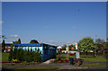
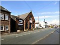
Information centre, Lancaster Road
This centre is run by Irwell Vale Housing who are the successors to Manchester City Council in managing the local housing. The Manchester connection is reflected in Mancunian Road which can be seen behind. In the sky, you can see this area is under the flight path to Manchester Airport (the latest ash cloud must have cleared).
Image: © Bill Boaden
Taken: 17 May 2010
0.18 miles