IMAGES TAKEN NEAR TO
Stockport Road, MANCHESTER, M34 6DH
Introduction
This page details the photographs taken nearby to Stockport Road, M34 6DH by members of the Geograph project.
The Geograph project started in 2005 with the aim of publishing, organising and preserving representative images for every square kilometre of Great Britain, Ireland and the Isle of Man.

There are currently over 7.5m images from over14,400 individuals and you can help contribute to the project by visiting https://www.geograph.org.uk
Image Map
Images are licensed for reuse under creativecommons.org/licenses/by-sa/2.0
Notes
- Clicking on the map will re-center to the selected point.
- The higher the marker number, the further away the image location is from the centre of the postcode.
Image Listing (497 Images Found)
Images are licensed for reuse under creativecommons.org/licenses/by-sa/2.0
Image
Details
Distance
1
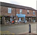
Shops on Stockport Road
This group of shops on Stockport Road, Denton include a sandwich shop, hairdressers, letting agent and carpet shop.
Image: © Gerald England
Taken: 22 Nov 2010
0.03 miles
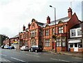
2
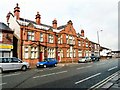
The Old Police Station
The former Lancashire Constabulary Police Station on Stockport Road has been converted into apartments. The new Police Point Image on Market Street is a much less grand building.
The Old Police Station is situated at 64 and 66 Stockport Road and it backs onto Market Street, which was the entrance for vehicles. It was formerly the Lancashire County Police Station and Petty Sessional Court for Ashton-under-Lyne and in the early 20th century cases were heard there on a fortnightly basis. It was built in 1896 and magistrates sat in the court for the first time on Friday, 4 February 1898. http://www.pittdixon.go-plus.net/denton/police-station.htm
Image: © Gerald England
Taken: 24 Aug 2009
0.04 miles
4
Denton Old Police Station
The former Lancashire Constabulary Police Station on Stockport Road has been converted into apartments. The new Police Point Image on Market Street is a much less grand building.
The Old Police Station is situated at 64 and 66 Stockport Road and it backs onto Market Street, which was the entrance for vehicles. It was formerly the Lancashire County Police Station and Petty Sessional Court for Ashton-under-Lyne and in the early 20th century cases were heard there on a fortnightly basis. It was built in 1896 and magistrates sat in the court for the first time on Friday, 4 February 1898. http://www.pittdixon.go-plus.net/denton/police-station.htm
Image: © Gerald England
Taken: 24 Aug 2009
0.05 miles
5
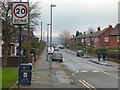
St Lawrence Road
Off Stockport Road. In an effort to discourage motorists using it as a "rat-run" it has a 20mph speed limit, road humps and other traffic-calming measures.
Image: © Gerald England
Taken: 18 Jan 2016
0.05 miles
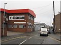
6
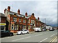
Former police station
On Stockport Road. This frontage has four doors each with an engraved stone header for Constable, Sergeant, Magistrates and Police.
Image: © Kevin Waterhouse
Taken: 30 May 2024
0.05 miles
7
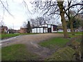
St Lawrence's, Denton
A modern building in the grounds of St Lawrence's church which is used for meetings and social events.
Image: © Gerald England
Taken: 18 Jan 2016
0.05 miles
8
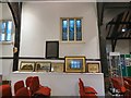
Heritage Open Day display
A display at St Lawrence's for the Heritage Open Day 2016.
Image: © Gerald England
Taken: 8 Sep 2016
0.06 miles
9
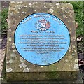
Blue Plaque: Church of St Lawrence
One of two blue plaques Image at St Lawrence's.
This one reads:
TAMESIDE METROPOLITAN BOROUGH
CHURCH OF ST LAWRENCE
Built early Sixteenth Century and originally dedicated to
St James until the discovery in the mid-nineteenth century
of a stained glass window to St Lawrence.
Affectionately known as 'Th'Owd Peg' because its framework
was fastened together with wooden pegs.
Resting place of John Angier, the famous Puritan divine
and of Colonel Robert Duckenfield, Tameside's
Civil War hero.
Image: © Gerald England
Taken: 18 Jan 2016
0.06 miles