IMAGES TAKEN NEAR TO
Hanover Street South, MANCHESTER, M34 5TQ
Introduction
This page details the photographs taken nearby to Hanover Street South, M34 5TQ by members of the Geograph project.
The Geograph project started in 2005 with the aim of publishing, organising and preserving representative images for every square kilometre of Great Britain, Ireland and the Isle of Man.

There are currently over 7.5m images from over14,400 individuals and you can help contribute to the project by visiting https://www.geograph.org.uk
Image Map
Images are licensed for reuse under creativecommons.org/licenses/by-sa/2.0
Notes
- Clicking on the map will re-center to the selected point.
- The higher the marker number, the further away the image location is from the centre of the postcode.
Image Listing (172 Images Found)
Images are licensed for reuse under creativecommons.org/licenses/by-sa/2.0
Image
Details
Distance
1
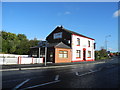
Plaza, Audenshaw Road - Guide Bridge (1)
Formerly the Church Inn (according to the locals the pub closed in the late 1990s), now a restaurant and take away. Yet another pub closed.
Image: © John Topping
Taken: 17 Oct 2012
0.04 miles
2
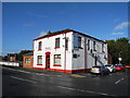
Plaza, Audenshaw Road - Guide Bridge (2)
On the corner with Hanover Street North.
Image: © John Topping
Taken: 17 Oct 2012
0.04 miles
3
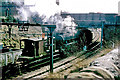
Freight train starting off towards Guide Bridge, 1968
A photograph of a long-gone railway connection from a long-gone road - Junction View. In the last year of steam, 45330 and train start away from a signal stop and pass under Audenshaw Road. The bridge also has now gone, a new bridge and junction with a new road is roughly where the camera is. The 1500 V DC electrification is also a thing of the past.
Image: © Robin Webster
Taken: Unknown
0.05 miles
4
Guide Bridge Theatre
The theatre was originally founded in 1941 and in 1972 it acquired its own premises on Audenshaw Road, converting them into a 116 seat theatre and bar. The buildings have been substantially improved and in 2012 it carried out a major upgrade of auditorium seating with grant aid from Sita Trust and the St. Modwen Environmental Trust. https://www.gbtheatre.co.uk/whoarewe.html
Image: © Gerald England
Taken: 11 Aug 2018
0.07 miles
5
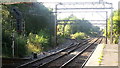
Guide Bridge Station Junction
Formerly Guide Bridge West Junction, the location has changed little in 25 years (see http://www.geograph.org.uk/photo/827960 ) apart from vegetation slowly enveloping the site.
Image: © Peter Whatley
Taken: 28 Sep 2013
0.07 miles
6
Guide Bridge Theatre
The theatre has a 70 year history, and is a popular and intimate 118-seat non professional theatre.
Image: © John Topping
Taken: 30 Apr 2012
0.07 miles
7
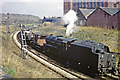
Waiting for the junction signal
A photograph of a long-gone railway connection from a long-gone road - Junction View. In the last year of steam, 45330 and train wait for the signal to join the main line through Guide Bridge. The 1500 V DC electrification is also a thing of the past. It only seems to extend a short way along this connecting spur.
Image: © Robin Webster
Taken: Unknown
0.08 miles
8
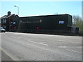
The A6140 at Audenshaw
The stretch of road to the right is the A6140 which was built to connect with M60/A635 junction. It leads off the B6390 Audenshaw Road. Beyond the motorway is the Snipe retail park as located by the B&Q blimp Image which is flying overhead.
Image: © Gerald England
Taken: 13 Jun 2015
0.08 miles
9
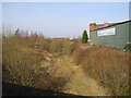
Old railway trackbed, Audenshaw
The old railway trackbed of the Guide Bridge (Stockport Junction) to Crowthorn Junction line (Closed and lifted during the early 1980's), where it joined the Denton Junction to Ashton Moss South Junction line.
Image: © John Topping
Taken: 4 Mar 2013
0.08 miles
10
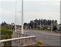
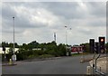
The A6140
A new road connecting Audenshaw with Droylsden and providing access to the M60 motorway.
Image: © Gerald England
Taken: 30 Jun 2009
0.09 miles