IMAGES TAKEN NEAR TO
Granville Road, MANCHESTER, M34 5SX
Introduction
This page details the photographs taken nearby to Granville Road, M34 5SX by members of the Geograph project.
The Geograph project started in 2005 with the aim of publishing, organising and preserving representative images for every square kilometre of Great Britain, Ireland and the Isle of Man.

There are currently over 7.5m images from over14,400 individuals and you can help contribute to the project by visiting https://www.geograph.org.uk
Image Map
Images are licensed for reuse under creativecommons.org/licenses/by-sa/2.0
Notes
- Clicking on the map will re-center to the selected point.
- The higher the marker number, the further away the image location is from the centre of the postcode.
Image Listing (59 Images Found)
Images are licensed for reuse under creativecommons.org/licenses/by-sa/2.0
Image
Details
Distance
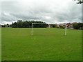
1
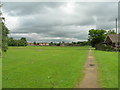
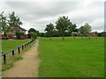
Path Alongside Leigh Drive, Droylsden
Looking to Lees Park playing field.
Image: © John Topping
Taken: 18 Jul 2012
0.09 miles
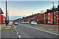
3
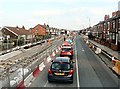
Droylsden Road
Traffic jams on Droylsden Road caused by the Metrolink extension to Ashton under construiction along the A662.
Image: © Gerald England
Taken: 1 Mar 2012
0.13 miles
5
Path leading to Ashton Road, Droylsden
Southwest path through Lees Park, Fairlee Avenue on the left.
Image: © John Topping
Taken: 18 Jul 2012
0.13 miles
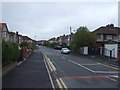
6
Droylsden Road
The A662 between Droylsden and Audenshaw.
Image: © David Dixon
Taken: 14 Nov 2021
0.14 miles
8
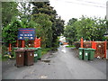
Entrance to Aldwinians R.U.F.C. - Audenshaw
It was wheelie bin collection day.
Image: © John Topping
Taken: 4 Oct 2012
0.15 miles
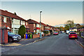
9
Lynwood Grove, Droylsden
Looking south from Lees Park, to the right is Fairlee Avenue.
Image: © John Topping
Taken: 18 Jul 2012
0.16 miles
10

Bancroft Service Station, 17 Droylsden Road, Droylsden
This is a BP filling station, and Mace convenience store, with a car wash on the same site.
Image: © P L Chadwick
Taken: 7 May 2011
0.16 miles