IMAGES TAKEN NEAR TO
Windsor Drive, MANCHESTER, M34 5RA
Introduction
This page details the photographs taken nearby to Windsor Drive, M34 5RA by members of the Geograph project.
The Geograph project started in 2005 with the aim of publishing, organising and preserving representative images for every square kilometre of Great Britain, Ireland and the Isle of Man.

There are currently over 7.5m images from over14,400 individuals and you can help contribute to the project by visiting https://www.geograph.org.uk
Image Map
Images are licensed for reuse under creativecommons.org/licenses/by-sa/2.0
Notes
- Clicking on the map will re-center to the selected point.
- The higher the marker number, the further away the image location is from the centre of the postcode.
Image Listing (84 Images Found)
Images are licensed for reuse under creativecommons.org/licenses/by-sa/2.0
Image
Details
Distance
1
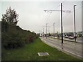
Tramlines at The Snipe
The Metrolink tramlines to Ashton under Lyne run alongside the A635. The tramlines run behind the Snipe Inn to run alongside the A6140 whilst the road runs in front of the inn.
Image: © Gerald England
Taken: 18 Nov 2013
0.03 miles
2
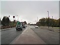
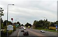
Approaching Audenshaw
On the A635 at "The Snipe". The road divides up ahead with the A635 continuing through Openshaw to Manchester and the A662 reaching Manchester via Droylsden.
Image: © Gerald England
Taken: 18 Nov 2013
0.05 miles
4
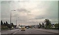
Manchester Road, Snipe
Manchester Road, passing through the area of Audenshaw known as "The Snipe". The area is unrecognisable from its appearance in the 1960s. This is just about where the railway bridge crossed over the road. To the right, where the retail park now stands, was Moss Colliery (also known as Snipe Colliery). To the left were the open fields of Ashton Moss; now covered by industrial units and a large motorway junction.
Image: © David Dixon
Taken: 20 Jul 2010
0.05 miles
5
Welcome to Audenshaw
The A635 passing the Snipe Retail Park approaching Ryecroft.
Image: © Gerald England
Taken: 6 Sep 2010
0.05 miles
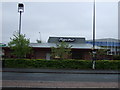
6
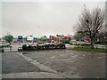
Snipe Retail Park
On the site of a former colliery.
Image: © Gerald England
Taken: 18 Nov 2013
0.06 miles
7
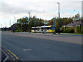
Audenshaw: Street-running Metrolink
Between Clayton Hall and beyond Audenshaw, Metrolink's latest extension is mostly street-running along wide roads. Here a car bound for Ashton is seen just east of the Audenshaw stop.
Image: © Dr Neil Clifton
Taken: 22 Nov 2013
0.07 miles
8
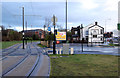
Tramway at The Snipe Inn
The Snipe was always an important point on the original tramway between Manchester and Ashton, as it marked the boundary between the Manchester and Ashton tramway, and later trolleybus, networks. The new tramway passes the rear of the pub, rather than running in the main road as the old tramway did.
Image: © Alan Murray-Rust
Taken: 7 Jan 2014
0.07 miles
9
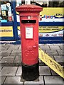
Closed GR Postbox M34 200
Georgian postbox M34 200 on Droylsden Road, Audenshaw. The posting slot is closed.
Image: © Gerald England
Taken: 9 Dec 2013
0.08 miles
10
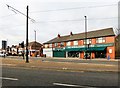
Shops at Audenshaw
The Metrolink runs through the junction of the A635 and A662. Across the latter road is the Wheelchair Centre. Next door is a funeral directors and on the left behind the postbox Image there used to a Post Office and later a general store but now it is a dog grooming parlour.
Image: © Gerald England
Taken: 12 Feb 2019
0.08 miles