IMAGES TAKEN NEAR TO
Audenshaw Road, MANCHESTER, M34 5HD
Introduction
This page details the photographs taken nearby to Audenshaw Road, M34 5HD by members of the Geograph project.
The Geograph project started in 2005 with the aim of publishing, organising and preserving representative images for every square kilometre of Great Britain, Ireland and the Isle of Man.

There are currently over 7.5m images from over14,400 individuals and you can help contribute to the project by visiting https://www.geograph.org.uk
Image Map
Images are licensed for reuse under creativecommons.org/licenses/by-sa/2.0
Notes
- Clicking on the map will re-center to the selected point.
- The higher the marker number, the further away the image location is from the centre of the postcode.
Image Listing (206 Images Found)
Images are licensed for reuse under creativecommons.org/licenses/by-sa/2.0
Image
Details
Distance
1
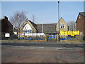
St. Stephen's CE Primary School, Audenshaw
This year the school is celebrating 150 years of education in Audenshaw 1863 - 2013.
Image: © John Topping
Taken: 4 Mar 2013
0.01 miles
2
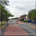
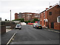
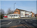
Audenshaw Road
The A6140 is the Ashton under Lyne western bypass http://www.sabre-roads.org.uk/wiki/index.php?title=A6140 which starts at traffic lights at the junction of Stockport Road and Guide Lane Image and heads west along Audenshaw Road. This part of the A6140 was formerly the eastern end of the B6390.
Image: © Gerald England
Taken: 13 Jun 2015
0.03 miles
3
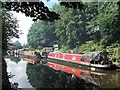
Ashton Canal
Narrow boats moored at Guide Bridge
Image: © michael ely
Taken: 1 Aug 2017
0.04 miles
4
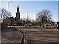
Guide Bridge junction
Busy road junction where the A6017 Ashton to Stockport road meets the B6390 carrying traffic which has just left the M60.
Image: © David Dixon
Taken: 30 Jan 2010
0.04 miles
5
York Street, Guide Bridge - Audenshaw
Leading to Poland Street and the recycling centre with Guide Bridge mill behind.
Image: © John Topping
Taken: 18 Oct 2012
0.04 miles
8
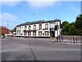
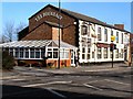
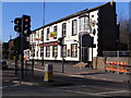
The Boundary
On the boundary between Audenshaw, Manchester and Ashton, Lancashire but now entirely within Tameside. The pub is closed again. It has closed and re-opened before but its future is probably precarious to say the least. The nearby Junction Inn has been recently demolished Image
It re-opened in January 2013 Image
Image: © Gerald England
Taken: 21 May 2012
0.05 miles
9
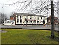
The Boundary, Audenshaw
The Boundary which was open in 2008 Image but closed in 2010 Image and 2012 Image re-opened in 2013.
Image: © Gerald England
Taken: 15 Feb 2013
0.05 miles
10
The Boundary, Guide Bridge
Formerly The Railway, re-named during the 1970’s to The Boundary. The pub is having a paint job done on the window frames, having recently re-opened on 14-1-13. See Gerald England's photo for more information.
Image: © John Topping
Taken: 4 Mar 2013
0.05 miles