IMAGES TAKEN NEAR TO
Ryecroft View, MANCHESTER, M34 5GE
Introduction
This page details the photographs taken nearby to Ryecroft View, M34 5GE by members of the Geograph project.
The Geograph project started in 2005 with the aim of publishing, organising and preserving representative images for every square kilometre of Great Britain, Ireland and the Isle of Man.

There are currently over 7.5m images from over14,400 individuals and you can help contribute to the project by visiting https://www.geograph.org.uk
Image Map
Images are licensed for reuse under creativecommons.org/licenses/by-sa/2.0
Notes
- Clicking on the map will re-center to the selected point.
- The higher the marker number, the further away the image location is from the centre of the postcode.
Image Listing (67 Images Found)
Images are licensed for reuse under creativecommons.org/licenses/by-sa/2.0
Image
Details
Distance
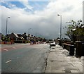
3
Droylsden Road
Looking West along the A662 from near Kenilworth Grove.
Image: © Gerald England
Taken: 9 Jun 2011
0.07 miles
4
End of Lumb Lane
The houses in the background are on Lumb Lane. The inside of the triangle formed by Lumb Lane, Manchester Road (the A635) and Droylsden Road (the A662) used to have nice semi-detached houses along Lumb Lane and Manchester Road, whilst there was filling station on Droylsden Road. The houses and filling station were demolished when the Metrolink extension to Ashton was first mooted. Later high hedges were planted around the site. Currently the area is being used as a storage and operational site for work on the Metrolink.
Image: © Gerald England
Taken: 6 Sep 2010
0.08 miles
5
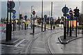
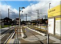
A proliferation of poles
The road junction at the east end of Audenshaw tram stop. One wonders whether some rationalisation of signing could be made and if the heavy bases to the poles are really justified.
Image: © Alan Murray-Rust
Taken: 7 Jan 2014
0.08 miles
6
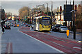
Tram on Droylsden Road
On the approach to Audenshaw tram stop. This is the final section of street running on this route.
Image: © Alan Murray-Rust
Taken: 7 Jan 2014
0.09 miles
7
Droylsden Road
The A662 towards Ashton from near Kenilworth Grove. The roadworks are in conjunction with the construction of the Metrolink expansion.
Image: © Gerald England
Taken: 9 Jun 2011
0.09 miles
8
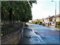
Lumb Lane
By the side of Ryecroft Hall.
Image: © Gerald England
Taken: 9 Jun 2011
0.09 miles
9
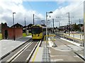
Audenshaw Tram Stop
As a tram for Bury departs Audenshaw, the tram for Ashton is coming round the corner.
Image: © Gerald England
Taken: 9 Oct 2013
0.10 miles
10
Audenshaw Tram Stop
The Metrolink stop on the line to Ashton under Lyne opened to passengers on 9th October 2013.
Image: © Gerald England
Taken: 9 Oct 2013
0.10 miles