IMAGES TAKEN NEAR TO
Lady Lane, MANCHESTER, M34 5FR
Introduction
This page details the photographs taken nearby to Lady Lane, M34 5FR by members of the Geograph project.
The Geograph project started in 2005 with the aim of publishing, organising and preserving representative images for every square kilometre of Great Britain, Ireland and the Isle of Man.

There are currently over 7.5m images from over14,400 individuals and you can help contribute to the project by visiting https://www.geograph.org.uk
Image Map
Images are licensed for reuse under creativecommons.org/licenses/by-sa/2.0
Notes
- Clicking on the map will re-center to the selected point.
- The higher the marker number, the further away the image location is from the centre of the postcode.
Image Listing (46 Images Found)
Images are licensed for reuse under creativecommons.org/licenses/by-sa/2.0
Image
Details
Distance
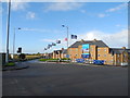
1
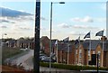
The Grange
New housing on Kings Road, Audenshaw.
Image: © Gerald England
Taken: 28 Nov 2012
0.02 miles
2
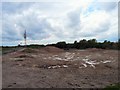
Reclaimed Land
Former industrial land off Audenshaw Road and Kings Road "reclaimed for future use". The probability is that it will be used for housing.
Image: © Gerald England
Taken: 6 May 2009
0.02 miles
3
The Grange
New housing on Kings Road, Audenshaw.
Image: © Gerald England
Taken: 28 Nov 2012
0.02 miles
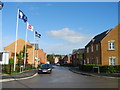
5
King's Road - Fairfield
For the Grange Housing Estate.
Image: © John Topping
Taken: 17 Oct 2012
0.03 miles
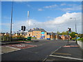
6

Kings Road
Road from Audenshaw to Debdale used as part of the Tameside Trail. On one side is the M60 motorway Image and on the other is recently reclaimed industrial land Image
Image: © Gerald England
Taken: 6 May 2009
0.03 miles
7
Baroness Road, Fairfield
At the junction with King's Road.
Image: © John Topping
Taken: 17 Oct 2012
0.04 miles
8
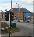
The Grange Road Junction - Fairfield
Junction for King's Road off the B6390 Audenshaw Road.
Image: © John Topping
Taken: 17 Oct 2012
0.05 miles
9
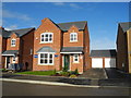
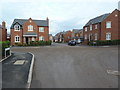
House sold on King's Road - Fairfield
The Grange Housing Development.
Image: © John Topping
Taken: 17 Oct 2012
0.06 miles
10

M60 motorway signs for junction 23
J23 signs on the approach from the south, viewed from King's Road - Fairfield.
Image: © John Topping
Taken: 17 Oct 2012
0.06 miles