IMAGES TAKEN NEAR TO
Mayfield Street, MANCHESTER, M34 5EU
Introduction
This page details the photographs taken nearby to Mayfield Street, M34 5EU by members of the Geograph project.
The Geograph project started in 2005 with the aim of publishing, organising and preserving representative images for every square kilometre of Great Britain, Ireland and the Isle of Man.

There are currently over 7.5m images from over14,400 individuals and you can help contribute to the project by visiting https://www.geograph.org.uk
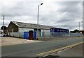
Image Map
Images are licensed for reuse under creativecommons.org/licenses/by-sa/2.0
Notes
- Clicking on the map will re-center to the selected point.
- The higher the marker number, the further away the image location is from the centre of the postcode.
Image Listing (29 Images Found)
Images are licensed for reuse under creativecommons.org/licenses/by-sa/2.0
Image
Details
Distance
1
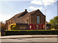
St Hilda's, Audenshaw
The parish church of St Hilda was opened in 1938, replacing an earlier one which had burned down in 1936.
http://www.sainthildaaudenshaw.moonfruit.com/# - St Hilda's web site
Image: © David Dixon
Taken: 3 Jun 2011
0.02 miles
2
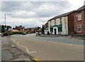
Ashton Road
The A6017 at the boundary between Denton and Audenshaw.
Image: © Gerald England
Taken: 22 Jun 2017
0.02 miles
3

St Hilda's, Audenshaw
A new district of St Hilda's was created in 1924 and a church was built on the current site. It was destroyed by a fire in 1936 and the present church was opened in 1938. For a more detailed history see Audenshaw Local History: http://web.archive.org/web/20170829115549/http://www.audenshawlocalhistory.org.uk/st_hildas.htm
Church website: http://www.sainthildas.net/
Image: © Gerald England
Taken: 27 Mar 2017
0.02 miles
4
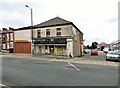
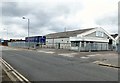
Threeways D-I-Y
Shop on the corner of Ashton Road and Hartford Street. It also has a warehouse on Hartford Street at the end of which is Mistry Motors.
Note: Photograph is for record purposes only. The photographer has no personal connection with the businesses depicted.
Image: © Gerald England
Taken: 22 Jun 2017
0.06 miles
5
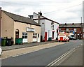
The Full Monty
Sandwich bar and cafe on Egerton Street.
Note: Photograph is for record purposes only. The photographer has no personal connection with the business depicted.
Image: © Gerald England
Taken: 22 Jun 2017
0.08 miles
6
Eastlight Factory
The Eastlight factory on Egerton Street is home to Plastoreg who have been manufacturing office products since 1976. http://denton.plastoreg.com/index.php?id=3&L=1 The German firm took it over from its previous owners ACCO in 2012 https://www.opi.net/news/acco-sells-uk-production-site/
Note: Photograph is for record purposes only. The photographer has no personal connection with the business depicted.
Image: © Gerald England
Taken: 22 Jun 2017
0.10 miles
7
Eastlight Factory
The Eastlight factory on Egerton Street is home to Plastoreg who have been manufacturing office products since 1976. http://denton.plastoreg.com/index.php?id=3&L=1 The German firm took it over from its previous owners ACCO in 2012 https://www.opi.net/news/acco-sells-uk-production-site/
Note: Photograph is for record purposes only. The photographer has no personal connection with the business depicted.
Image: © Gerald England
Taken: 22 Jun 2017
0.10 miles
8
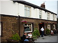
The White House Inn
A Sam Smith's public house
Image: © Ian S
Taken: 4 Jul 2011
0.11 miles
9
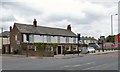
White House Inn
A Sam Smith's pub on Ashton Road.
Image
Image: © Gerald England
Taken: 22 Jun 2017
0.11 miles
10
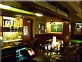
The White House Inn
One of the bars in this Sam Smith's public house
Image: © Ian S
Taken: 4 Jul 2011
0.11 miles