IMAGES TAKEN NEAR TO
Hazelwood Drive, MANCHESTER, M34 5ED
Introduction
This page details the photographs taken nearby to Hazelwood Drive, M34 5ED by members of the Geograph project.
The Geograph project started in 2005 with the aim of publishing, organising and preserving representative images for every square kilometre of Great Britain, Ireland and the Isle of Man.

There are currently over 7.5m images from over14,400 individuals and you can help contribute to the project by visiting https://www.geograph.org.uk
Image Map
Images are licensed for reuse under creativecommons.org/licenses/by-sa/2.0
Notes
- Clicking on the map will re-center to the selected point.
- The higher the marker number, the further away the image location is from the centre of the postcode.
Image Listing (54 Images Found)
Images are licensed for reuse under creativecommons.org/licenses/by-sa/2.0
Image
Details
Distance
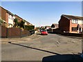
2
Guide Lane, Audenshaw
The road used to run to the left of the Sun Inn, which is in the centre background. Junction improvements have enabled it to run straight onto Denton Road beyond the traffic lights. The building on the left is a disused Methodist chapel.
Image: © Bill Boaden
Taken: 26 Apr 2010
0.05 miles
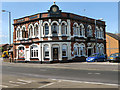
3
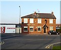
Old Pack Horse
The Old Pack Horse Inn on Stamford Road at Audenshaw.
Image: © Gerald England
Taken: 29 Dec 2008
0.05 miles
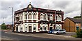
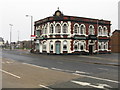
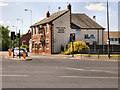
6
The Sun Inn
Large traditional pub on the corner of Guide Lane and Shepley Road. Although closed for a time it was open again in 2012.
Image: © Gerald England
Taken: 19 Jun 2012
0.06 miles
7
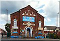
Guide Lane Methodist Church
The Wesley Methodist Society was formed in Hooley Hill in 1786 by a dissident group of members from the Red Hall Methodist Church, Audenshaw.
In 1806 a new purpose built Chapel and Sunday School was built. A large cottage adjacent to the Chapel was converted for school use with the girls taught upstairs and the boys downstairs. A new school building was added in 1855. This building was then replaced in 1901 by the two-storey school which was in use until 1950.
The buildings on Guide Lane were closed in 2004. The fellowship joined with Bridge Street United Reformed Church Image Image and Red Hall Methodist Church Image to form Trinity Church Image on Audenshaw Road, Audenshaw.
Read the account of Hooley Hill (Wesleyans) Methodist Church 1796 -2004 by Ralph Smethurst former Steward of the Church http://web.archive.org/web/20080723165127/http://www.audenshawlocalhistory.org/page42a.html
The building is now the home of the Little Giggles Private Day Nursery. http://www.littlegigglesnursery.co.uk/
Image: © Gerald England
Taken: 19 Jun 2012
0.06 miles
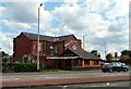
8
Houses at Hooley Hill
Off Guide Lane.
Image: © Gerald England
Taken: 27 Mar 2017
0.06 miles
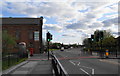
9
Old Pack Horse
Looking across the crossroads of Guide Lane, Shepley Road, Denton Road and Stamford Road, towards the Old Pack Horse public house.
Image: © David Dixon
Taken: 3 Jun 2011
0.06 miles
10
The Sun Inn, Audenshaw
The Sun Inn on Shepley Road.
This pub, a local landmark at the junction of Guide Lane, Shepley Road, Denton Road and Stamford Road, has reopened since Image] was taken in January 2010.
Image: © David Dixon
Taken: 3 Jun 2011
0.06 miles