IMAGES TAKEN NEAR TO
Acre Street, MANCHESTER, M34 2BW
Introduction
This page details the photographs taken nearby to Acre Street, M34 2BW by members of the Geograph project.
The Geograph project started in 2005 with the aim of publishing, organising and preserving representative images for every square kilometre of Great Britain, Ireland and the Isle of Man.

There are currently over 7.5m images from over14,400 individuals and you can help contribute to the project by visiting https://www.geograph.org.uk
Image Map
Images are licensed for reuse under creativecommons.org/licenses/by-sa/2.0
Notes
- Clicking on the map will re-center to the selected point.
- The higher the marker number, the further away the image location is from the centre of the postcode.
Image Listing (608 Images Found)
Images are licensed for reuse under creativecommons.org/licenses/by-sa/2.0
Image
Details
Distance
1
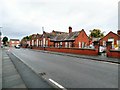
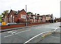
Dental Central Primary School and ASD Resource Base
Originally known as Denton Council School, the buildings on Duke Street were converted to a military hospital during the First World War. During the Second World War it was used as a first aid station, run by the St John Ambulance Brigade.
It is now Dental Central Primary School and ASD Resource Base, Manchester. The main entrance is on Acre Street Image Another part of the school was used as a Young People's Centre Image but that is now closed and for sale.
Image: © Gerald England
Taken: 5 Oct 2015
0.02 miles
2
Denton Central Primary School
Originally known as Denton Council School, the buildings on Duke Street were converted to a military hospital during the First World War. During the Second World War it was used as a first aid station, run by the St John Ambulance Brigade.
It is now Dental Central Primary School and ASD Resource Base Image, Manchester. The main entrance is on Acre Street. Another part of the school was used as a Young People's Centre Image but that is now closed and for sale.
Image: © Gerald England
Taken: 5 Oct 2015
0.02 miles
3
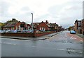
Duke Street
On the left is what was Denton Council School. The buildings were converted to a military hospital during the First World War. During the Second World War it was used as a first aid station, run by the St John Ambulance Brigade.
It is now Dental Central Primary School and ASD Resource Base, Manchester Image The main entrance is on Acre Street. A separate part of the school further down Duke Street was used as a Young People's Centre Image but that is now closed and for sale.
Image: © Gerald England
Taken: 5 Oct 2015
0.02 miles
4
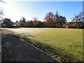
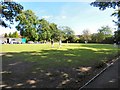
Ladies' Bowling Green
One of two greens in Victoria Park.
Image: © Gerald England
Taken: 2 Nov 2015
0.02 miles
5
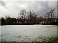
Ladies Bowling Green
The ladies bowling green in Victoria Park covered in the first snow of winter 2011/12.
Image: © Gerald England
Taken: 5 Dec 2011
0.03 miles
6
The Ladies' Bowling Green
Play continues in Victoria Park during the Denton Carnival.
Image: © Gerald England
Taken: 11 Sep 2016
0.03 miles
7
The Ladies' Bowling Green
Not all the bowlers are of the female gender. The Denton Carnival was in full swing all around them.
Image: © Gerald England
Taken: 11 Sep 2016
0.03 miles
8
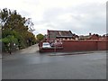
Former Young People's Centre
Part of what was originally Denton Council School Image on Duke Street is the former Young People's Centre Image which is currently (October 2015) closed and up for sale for offers in the region of £250,000. The property is described as comprising a single storey brick built premises beneath a pitched slate roof. Internally the property is split into circa 20 rooms comprising offices, meeting rooms, large central hall, stores and kitchen/WC facilities. There is a mix of vinyl, laminate and carpeted flooring, fluorescent strip lights and some rooms with suspended ceilings. Externally there is a yard to the rear and some smaller out buildings for storage.
Image: © Gerald England
Taken: 5 Oct 2015
0.03 miles
9
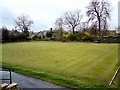
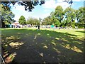
Victoria Park Bowling Green
One of the two bowling greens in Victoria Park, Denton.
Image: © Gerald England
Taken: 26 Apr 2010
0.03 miles
10
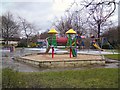
Victoria Park Play Area
Children's play area at Victoria Park.
Image: © Gerald England
Taken: 5 Dec 2011
0.03 miles