IMAGES TAKEN NEAR TO
Leftbank, MANCHESTER, M3 3AG
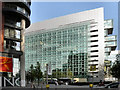
Introduction
This page details the photographs taken nearby to Leftbank, M3 3AG by members of the Geograph project.
The Geograph project started in 2005 with the aim of publishing, organising and preserving representative images for every square kilometre of Great Britain, Ireland and the Isle of Man.

There are currently over 7.5m images from over14,400 individuals and you can help contribute to the project by visiting https://www.geograph.org.uk
Image Map
Images are licensed for reuse under creativecommons.org/licenses/by-sa/2.0
Notes
- Clicking on the map will re-center to the selected point.
- The higher the marker number, the further away the image location is from the centre of the postcode.
Image Listing (812 Images Found)
Images are licensed for reuse under creativecommons.org/licenses/by-sa/2.0
Image
Details
Distance
1

Do you know where you're going to?
From the font used I presume this is a reference to the ice rink across the bridge
Image: © Anthony Parkes
Taken: 3 Jan 2016
0.02 miles
2
Spinningfields, Manchester
The corner of Left Bank and Hardman Boulevard.
Image: © David Dixon
Taken: 22 Apr 2011
0.02 miles
3
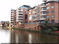
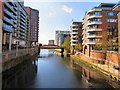
Ralli Quays, Salford
Ralli Quays by the Irwell includes offices of HM Revenue and Customs. View across the river from Manchester.
Image: © David Hawgood
Taken: 14 Jan 2009
0.02 miles
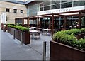
4

Left Bank
On the Manchester side of the River Irwell in the area now called Spinningfields. It contains a number of cafe bars and restaurants with outside eating areas for when the weather is fine.
Image: © Gerald England
Taken: 16 Dec 2017
0.02 miles
5
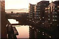
Manchester: view down the Irwell from the People's History Museum
Image: © Christopher Hilton
Taken: 19 Nov 1994
0.02 miles
6
Slug & Lettuce
The Slug & Lettuce Water Street Spinningfields Manchester.
Image: © Steve Houldsworth
Taken: 26 May 2018
0.02 miles
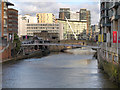
7
River Irwell at Spinningfields
View of the River Irwell and Irwell Street Bridge Image from the footbridge at Spinningfields.
Image: © Gerald England
Taken: 20 Apr 2018
0.03 miles
8
River Irwell at Spinningfields
A view through the cast-iron parapet of the Irwell Street bridge, looking towards New Bailey.
Image: © David Dixon
Taken: 4 Nov 2020
0.03 miles
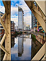
9
Spinningfields Footbridge
The River Irwell, has always marked the invisible border between the Cities of Manchester and Salford. Here, we are looking upstream from the bridge at New Quay Street Image] .
Ahead, is the new footbridge, which was opened in January 2012 (http://www.manchesterconfidential.co.uk/News/New-City-Centre-Footbridge-Lands report, Manchester Confidential) and is the latest part of the Irwell River Park Programme, providing a direct gateway between the New Bailey area of Salford Central and Spinningfields in Manchester.
Image: © David Dixon
Taken: 6 Feb 2013
0.03 miles
10
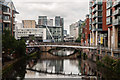
River Irwell
River Irwell, the boundary between Salford (left) and Manchester (right).
Image: © Peter McDermott
Taken: 19 Jul 2014
0.03 miles