IMAGES TAKEN NEAR TO
Cross Street, SALE, M33 7JR
Introduction
This page details the photographs taken nearby to Cross Street, M33 7JR by members of the Geograph project.
The Geograph project started in 2005 with the aim of publishing, organising and preserving representative images for every square kilometre of Great Britain, Ireland and the Isle of Man.

There are currently over 7.5m images from over14,400 individuals and you can help contribute to the project by visiting https://www.geograph.org.uk
Image Map
Images are licensed for reuse under creativecommons.org/licenses/by-sa/2.0
Notes
- Clicking on the map will re-center to the selected point.
- The higher the marker number, the further away the image location is from the centre of the postcode.
Image Listing (16 Images Found)
Images are licensed for reuse under creativecommons.org/licenses/by-sa/2.0
Image
Details
Distance
1
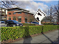
City Gate
The City Gate Business Park on the A56 (Cross Street), next to junction 7 of the M60 motorway.
Image: © David Dixon
Taken: 12 Jan 2012
0.02 miles
2
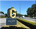
City Gate, Sale
A small business park on the northern edge of Sale. It has got a new sign since last Geographed in 2012. Image
Image: © Des Blenkinsopp
Taken: 30 Jun 2018
0.03 miles
3
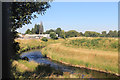
River Mersey behind the Travelodge
In an engineered channel with levees along here.
Image: © Des Blenkinsopp
Taken: 1 Jul 2018
0.07 miles
4
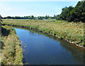
River Mersey from Crossford Bridge
Looking west (downstream) along the River Mersey from Crossford Bridge. The Mersey was the historic boundary between the counties of Lancashire (on the right as we look) and Cheshire (on the left side). Both sides are now in Greater Manchester.
Image: © David Dixon
Taken: 12 Jan 2012
0.08 miles
5
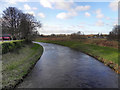
River Mersey at Crossford Bridge
A sign by the bridge marks this as the old border between Lancashire, on the right here, and Cheshire.
Image: © Des Blenkinsopp
Taken: 30 Jun 2018
0.10 miles
6
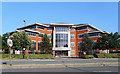
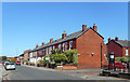
Cavendish House, Cross Street, Sale
Business premises occupied by Styles and Wood, who offer Integrated Property Services.
Image: © Des Blenkinsopp
Taken: 29 Jun 2018
0.10 miles
7
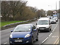
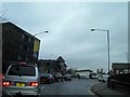
TGI Friday?
A queue of cars on the A56 awaits the traffic lights at the M60 intersection at the beginning of a Friday rush-hour. The vehicles are descending from the humped, curved bridge over the River Mersey which before 1974 marked the county boundary between Lancashire and, in the distance with the chain restaurant's sign, Cheshire.
Image: © Peter Whatley
Taken: 27 Feb 2009
0.13 miles
8
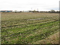
By The Mersey
Crop fields adjoin the Mersey (hidden from view) in a curious patch of farmland amongst south Manchester's suburbia, which has survived due to its potential to act as a flood relief zone.
Image: © Peter Whatley
Taken: 27 Feb 2009
0.14 miles