IMAGES TAKEN NEAR TO
Gordon Avenue, SALE, M33 6LD
Introduction
This page details the photographs taken nearby to Gordon Avenue, M33 6LD by members of the Geograph project.
The Geograph project started in 2005 with the aim of publishing, organising and preserving representative images for every square kilometre of Great Britain, Ireland and the Isle of Man.

There are currently over 7.5m images from over14,400 individuals and you can help contribute to the project by visiting https://www.geograph.org.uk
Image Map
Images are licensed for reuse under creativecommons.org/licenses/by-sa/2.0
Notes
- Clicking on the map will re-center to the selected point.
- The higher the marker number, the further away the image location is from the centre of the postcode.
Image Listing (16 Images Found)
Images are licensed for reuse under creativecommons.org/licenses/by-sa/2.0
Image
Details
Distance
1
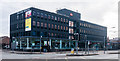
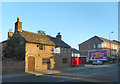
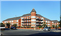
Dalton House
Dalton House, an office block in Sale.
Image: © Peter McDermott
Taken: 11 Oct 2014
0.08 miles
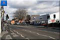
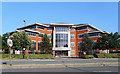
4
Mersey Road
A quiet suburban street which has a road name joining onto the busy A56 main road at a point where it's called Cross Street.
Image: © Mick Garratt
Taken: 6 Feb 2008
0.13 miles
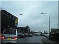
5
120 Cross Street, Sale
An unusual old survival from days gone by. It doesn't look occupied.
Image: © Des Blenkinsopp
Taken: 29 Jun 2018
0.15 miles
6
Cavendish House, Cross Street, Sale
Business premises occupied by Styles and Wood, who offer Integrated Property Services.
Image: © Des Blenkinsopp
Taken: 29 Jun 2018
0.15 miles
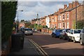
7
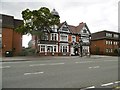
Sale, The Volunteer
Large Victorian pub on Cross Street (A56). Back bar drinking areas left, front and right; games machines, darts, TV. Cask ales on offer at my visit: Holt's Mild, Bitter. Listed in the 2015 Good Beer Guide.
Image: © Mike Faherty
Taken: 11 Aug 2015
0.17 miles
8
River Mersey behind the Travelodge
In an engineered channel with levees along here.
Image: © Des Blenkinsopp
Taken: 1 Jul 2018
0.17 miles
9
Corner turret on the block
Apartments on busy Cross Street and quieter Chapel Road.
Image: © Des Blenkinsopp
Taken: 29 Jun 2018
0.18 miles
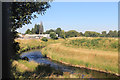
10
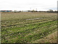
By The Mersey
Crop fields adjoin the Mersey (hidden from view) in a curious patch of farmland amongst south Manchester's suburbia, which has survived due to its potential to act as a flood relief zone.
Image: © Peter Whatley
Taken: 27 Feb 2009
0.19 miles