IMAGES TAKEN NEAR TO
Worcester Road, SALE, M33 5DS
Introduction
This page details the photographs taken nearby to Worcester Road, M33 5DS by members of the Geograph project.
The Geograph project started in 2005 with the aim of publishing, organising and preserving representative images for every square kilometre of Great Britain, Ireland and the Isle of Man.

There are currently over 7.5m images from over14,400 individuals and you can help contribute to the project by visiting https://www.geograph.org.uk
Image Map
Images are licensed for reuse under creativecommons.org/licenses/by-sa/2.0
Notes
- Clicking on the map will re-center to the selected point.
- The higher the marker number, the further away the image location is from the centre of the postcode.
Image Listing (5 Images Found)
Images are licensed for reuse under creativecommons.org/licenses/by-sa/2.0
Image
Details
Distance
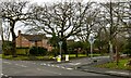
2
Manor Avenue, Sale
A view along Image but further north, where it runs alongside Image on the left. Seen from the junction with Harewood Avenue, north of which a service road on the right is separated from the main carriageways by a lawn and trees.
Image: © Derek Harper
Taken: 18 Aug 2010
0.15 miles
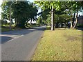
3
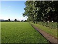
Recreation ground, Manor Avenue, Sale
2.87 hectares of playing area. Manor Avenue runs behind the hedge and trees on the right, down a bank.
Image: © Derek Harper
Taken: 18 Aug 2010
0.16 miles
4
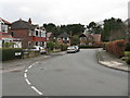
Ashton-upon-Mersey - Dorrington Road
A typical road in this pleasant, albeit sprawling south-west Manchester suburb.
Image: © Peter Whatley
Taken: 27 Feb 2009
0.22 miles
5
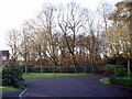
Broadlands Wood
Broadlands Wood set in a housing development that was originally Sale Boys Grammar School. The wood is now maintained by the Woodland Trust.
Image: © Norman Caesar
Taken: 19 Feb 2012
0.24 miles