IMAGES TAKEN NEAR TO
Chepstow Avenue, SALE, M33 4QP
Introduction
This page details the photographs taken nearby to Chepstow Avenue, M33 4QP by members of the Geograph project.
The Geograph project started in 2005 with the aim of publishing, organising and preserving representative images for every square kilometre of Great Britain, Ireland and the Isle of Man.

There are currently over 7.5m images from over14,400 individuals and you can help contribute to the project by visiting https://www.geograph.org.uk
Image Map
Images are licensed for reuse under creativecommons.org/licenses/by-sa/2.0
Notes
- Clicking on the map will re-center to the selected point.
- The higher the marker number, the further away the image location is from the centre of the postcode.
Image Listing (5 Images Found)
Images are licensed for reuse under creativecommons.org/licenses/by-sa/2.0
Image
Details
Distance
1
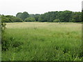
Hidden Meadow Of Sale
A few yards from the notorious Firsway estate is this patch of open grassland, adjacent to a path which leads to the Trans-Pennine Trail.
Image: © Peter Whatley
Taken: 1 Jul 2009
0.16 miles
2
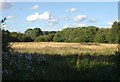
Meadow near Firs Way
This looks like the same view as Image, a little later in the summer. A drainage ditch runs along this side of the trees on the right, with Firs Way behind them.
Image: © Derek Harper
Taken: 18 Aug 2010
0.20 miles
3
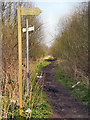
To The Shops
Sign on the Trans Pennine Trail.
Image: © David Dixon
Taken: 22 Mar 2012
0.20 miles
4
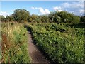
Trans-Pennine Trail
The trail, coupled with cyclepath NCN62, makes its way towards the edge of the built-up area of Sale at Firs Way.
Image: © Derek Harper
Taken: 18 Aug 2010
0.20 miles
5
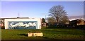
Mural on the rear of garages - Firsway Estate
Image: © Anthony Parkes
Taken: 20 Jan 2014
0.20 miles