IMAGES TAKEN NEAR TO
Briggs Close, SALE, M33 4NR
Introduction
This page details the photographs taken nearby to Briggs Close, M33 4NR by members of the Geograph project.
The Geograph project started in 2005 with the aim of publishing, organising and preserving representative images for every square kilometre of Great Britain, Ireland and the Isle of Man.

There are currently over 7.5m images from over14,400 individuals and you can help contribute to the project by visiting https://www.geograph.org.uk
Image Map (Loading...)


Getting Data...Please wait
Leaflet Map data © OpenStreetMap
Images are licensed for reuse under creativecommons.org/licenses/by-sa/2.0
Notes
- Clicking on the map will re-center to the selected point.
- The higher the marker number, the further away the image location is from the centre of the postcode.
Image Listing (6 Images Found)
Images are licensed for reuse under creativecommons.org/licenses/by-sa/2.0
Image
Details
Distance
1
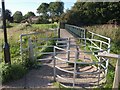
Gate and bridge over Sinderland Brook
This bridge connects the Woodhouses estate to Stamford Brook. A wide swathe of grass and woodland beside the brook provides a green buffer between the two.
Image: © Derek Harper
Taken: 18 Aug 2010
0.10 miles
2
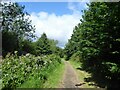
Path in Woodheys Park
A path following the north bank of Sinderland Brook
Image: © Kevin Waterhouse
Taken: 9 Aug 2024
0.16 miles
3
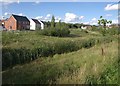
Reedy watercourse, Stamford Brook
A small tributary of the Sinderland Brook crosses the new housing development. Across it are new houses on Dipper Drive. Those on the right are on Collingham Road.
Image: © Derek Harper
Taken: 18 Aug 2010
0.18 miles
4
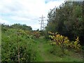
Path to Woodhouse Lane
A path that has followed Sinderland Brook turns away from the stream to join the lane
Image: © Kevin Waterhouse
Taken: 9 Aug 2024
0.22 miles
5
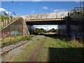
Bridge, Stamford Brook
The bridge carries Turnbull Road into the new housing development of Stamford Brook. The shadow in the right foreground is of the new Waitrose shown in Image
Image: © Derek Harper
Taken: 18 Aug 2010
0.24 miles
6

New supermarket, Broadheath
A new Waitrose on the edge of the new Stamford Brook housing development, and seen here from the trackbed of the former Cheshire Lines Committee railway line.
Image: © Derek Harper
Taken: 18 Aug 2010
0.25 miles