IMAGES TAKEN NEAR TO
Georges Road, SALE, M33 3NJ
Introduction
This page details the photographs taken nearby to Georges Road, M33 3NJ by members of the Geograph project.
The Geograph project started in 2005 with the aim of publishing, organising and preserving representative images for every square kilometre of Great Britain, Ireland and the Isle of Man.

There are currently over 7.5m images from over14,400 individuals and you can help contribute to the project by visiting https://www.geograph.org.uk
Image Map
Images are licensed for reuse under creativecommons.org/licenses/by-sa/2.0
Notes
- Clicking on the map will re-center to the selected point.
- The higher the marker number, the further away the image location is from the centre of the postcode.
Image Listing (8 Images Found)
Images are licensed for reuse under creativecommons.org/licenses/by-sa/2.0
Image
Details
Distance
1
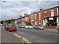
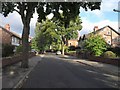
Marsland Road, Sale
The A6144, with Victorian buildings east of Brooklands metro station. Taken from the junction with The Grove.
Image: © Derek Harper
Taken: 18 Aug 2010
0.11 miles
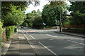
3
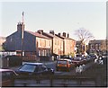
Crossroads on Wardle Road, Sale
Wardle Road is the main road. On the far side is Clifton Road. Taken from beneath a copper beech on Poplar Grove.
Image: © Derek Harper
Taken: 17 Aug 2010
0.15 miles
4
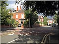
Highfield, Sale
Victorian semis along a no through road; the T-junction at the end is with Highfield Avenue, a cul-de-sac in each direction.
Image: © Derek Harper
Taken: 17 Aug 2010
0.18 miles
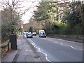
5
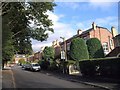
Norman Road, Sale
A leafy cul-de-sac off Wardle Road; the T-junction is in the background.
Image: © Derek Harper
Taken: 17 Aug 2010
0.21 miles
6
Brooklands Road, Sale.
A view down the long tree lined Brooklands Road in Sale with the junction of Bollin Drive just right of centre.
Image: © andy
Taken: 1 Jul 2005
0.22 miles
7
Brooklands Road from Whitehall Road
Brooklands Road reflects the historic estates and influence of the Brooks family around Sale and Timperley. The road heads dead straight from Brooklands station for over a mile and, as a walking route only, continues for almost another mile beyond the major roundabout now provided at the southern end of the vehicular road. For a photo of the southern end, see: [http://www.geograph.org.uk/photo/1134155].
Image: © Peter Whatley
Taken: 20 Jan 2009
0.24 miles
8
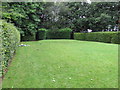
Theatre lawn, Walkden gardens Sale
This small public garden is divided by hedges into a number of sections. Since 2001 the Friends of Walkden Gardens have been presenting a variety of events in this space. There is a raised area acting as the stage at the end away from the camera. There had been a Shakespeare play presented here the night before the photo was taken.
Image: © David Hawgood
Taken: 20 Aug 2016
0.25 miles