IMAGES TAKEN NEAR TO
Southgate, MANCHESTER, M3 2RB
Introduction
This page details the photographs taken nearby to Southgate, M3 2RB by members of the Geograph project.
The Geograph project started in 2005 with the aim of publishing, organising and preserving representative images for every square kilometre of Great Britain, Ireland and the Isle of Man.

There are currently over 7.5m images from over14,400 individuals and you can help contribute to the project by visiting https://www.geograph.org.uk
Image Map (Loading...)


Getting Data...Please wait
Leaflet Map data © OpenStreetMap
Images are licensed for reuse under creativecommons.org/licenses/by-sa/2.0
Notes
- Clicking on the map will re-center to the selected point.
- The higher the marker number, the further away the image location is from the centre of the postcode.
Image Listing (1953 Images Found)
Images are licensed for reuse under creativecommons.org/licenses/by-sa/2.0
Image
Details
Distance
1
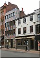
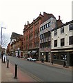
60-62 Bridge Street
62 Bridge Street was the offices of Saudi Arabian Airlines in 2008 before becoming the Sundowners Travel Centre (c2012). Now that has been converted into Grindsmith's coffee lounge.
The Bridge pub at #60 was originally The Bridge Street Tavern.
Image: © Gerald England
Taken: 11 Jan 2020
0.02 miles
2
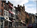
Buildings on Bridge Street, Manchester
On the north side of Bridge Street as it climbs towards Deansgate.
Image: © Derek Harper
Taken: 19 Aug 2010
0.02 miles
3
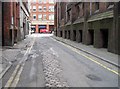
Wood Street, Manchester
This is looking along Wood Street to Deansgate. John Rylands Library is along the right, and there is a good view of the original setts beneath the tarmac. Once this narrow side-street would have been considered a main road.
Image: © Tricia Neal
Taken: 9 May 2012
0.02 miles
4
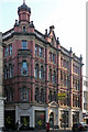
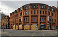
64 Bridge Street, Manchester
Aka Rational House. By Samuel Davidson, 1897. Red brick and stone dressings, windows recessed behind pairs of stone arches with pink granite columns and keystones of carved faces, and a small corner tower topped with an onion dome.
Image: © Stephen Richards
Taken: 23 Jun 2011
0.03 miles
5
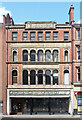
Bridge Street
One section of the A34 through Manchester.
The Bridge pub at #60 was originally The Bridge Street Tavern.
62 Bridge Street was the offices of Saudi Arabian Airlines in 2008 before becoming the Sundowners Travel Centre (c2012). Now that has been converted into Grindsmith's coffee lounge.
64 Bridge Street is Rational House, a four storey Victorian warehouse that has been converted into offices on the upper level and retail units on the ground. Some nine companies are registered at the address https://www.companieshousedata.co.uk/a/112552 The ground floor is occupied by outfitters Doherty Evans & Stott on one side and since 2017 by Randall & Aubin's brasserie restaurant https://www.randallandaubin.com/manchester/about.html on the other. Before that it had been "ligne roseet" aka "rankin styles".
Image: © Gerald England
Taken: 11 Jan 2020
0.03 miles
6
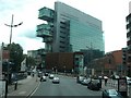
The city scape from New Bailey Street
Image: © Raymond Knapman
Taken: 24 Jun 2011
0.03 miles
8
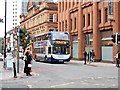
Bridge Street (A34), Manchester
Stagecoach Manchester's Enviro 400 (fleet no 19497, Reg MX09 ASU) at the junction of Bridge Street and Deansgate).
Image: © David Dixon
Taken: 4 Oct 2013
0.03 miles
9
Deansgate
Sainsbury's on the junction of Bridge Street and Deansgate, closed and boarded up as a result of COVID-19.
Image: © Peter McDermott
Taken: 5 Apr 2020
0.03 miles
10
126 Deansgate, Manchester
Quite an impressive facade and not without interest, although it is not listed. It is a happy blend of Victorian arcaded windows with foliage capitals, and a post-war fascia which is worth preserving.
It was built in the 1880s as part of a much larger warehouse for Henry Ogden, a cabinet maker. Information from http://manchesterhistory.net. It has clearly been occupied for some time by Forsyth Brothers, who describes itself as "the UK’s largest specialist music shop".
Image: © Stephen Richards
Taken: 24 Jul 2011
0.03 miles