IMAGES TAKEN NEAR TO
Bradley Lane, MANCHESTER, M32 8RH
Introduction
This page details the photographs taken nearby to Bradley Lane, M32 8RH by members of the Geograph project.
The Geograph project started in 2005 with the aim of publishing, organising and preserving representative images for every square kilometre of Great Britain, Ireland and the Isle of Man.

There are currently over 7.5m images from over14,400 individuals and you can help contribute to the project by visiting https://www.geograph.org.uk
Image Map (Loading...)


Getting Data...Please wait
Leaflet Map data © OpenStreetMap
Images are licensed for reuse under creativecommons.org/licenses/by-sa/2.0
Notes
- Clicking on the map will re-center to the selected point.
- The higher the marker number, the further away the image location is from the centre of the postcode.
Image Listing (12 Images Found)
Images are licensed for reuse under creativecommons.org/licenses/by-sa/2.0
Image
Details
Distance
1
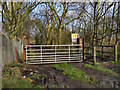
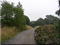
Path to Kickety Brook
The gate at the start of the path from Bradley Lane to Kickety Brook.
Image: © David Dixon
Taken: 12 Jan 2012
0.06 miles
2
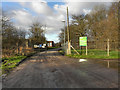
Stretford Wastewater Treatment Plant
The entrance to the Stretford wastewater treatment plant (sewage works) near Kickety Brook at the end of Bradley Lane.
Image: © David Dixon
Taken: 12 Jan 2012
0.08 miles
4
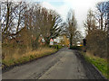
To The Sewage Works!
Perhaps that's why this road is rather quieter than most in the area.
Image: © Peter Whatley
Taken: 27 Feb 2009
0.21 miles
5
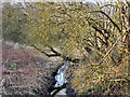
Kickety Brook
Looking along Kickety Brook from the Trans-Pennine Trail.
Image: © David Dixon
Taken: 12 Jan 2012
0.21 miles
6
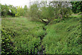
Kickety Brook
The brook is hardly visible through the foliage. It once assisted towards preventing flooding from the Mersey.
Image: © Bill Boaden
Taken: 9 May 2019
0.21 miles
7
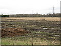
Stubble Surprise
Unexpected fields of crops in the Mersey Valley. The M60 is immediately behind the line of trees in the background.
Image: © Peter Whatley
Taken: 27 Feb 2009
0.22 miles
8
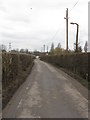
Trans Pennine Trail
A view eastwards along the Trans Pennine Trail near Stretford, Manchester. The Trail runs for over 200 miles and links the Irish Sea coast and the North Sea coast. SJ78499355.
Image: © Keith Williamson
Taken: 6 Sep 2005
0.22 miles
9
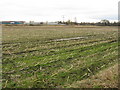
By The Mersey
Crop fields adjoin the Mersey (hidden from view) in a curious patch of farmland amongst south Manchester's suburbia, which has survived due to its potential to act as a flood relief zone.
Image: © Peter Whatley
Taken: 27 Feb 2009
0.22 miles
10
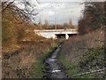
Path Under the Motorway
The path next to Kickety Brook passes under the M60 motorway, near to junction 7.
Image: © David Dixon
Taken: 12 Jan 2012
0.23 miles