IMAGES TAKEN NEAR TO
Hattons Court, MANCHESTER, M32 0AP
Introduction
This page details the photographs taken nearby to Hattons Court, M32 0AP by members of the Geograph project.
The Geograph project started in 2005 with the aim of publishing, organising and preserving representative images for every square kilometre of Great Britain, Ireland and the Isle of Man.

There are currently over 7.5m images from over14,400 individuals and you can help contribute to the project by visiting https://www.geograph.org.uk
Image Map
Images are licensed for reuse under creativecommons.org/licenses/by-sa/2.0
Notes
- Clicking on the map will re-center to the selected point.
- The higher the marker number, the further away the image location is from the centre of the postcode.
Image Listing (66 Images Found)
Images are licensed for reuse under creativecommons.org/licenses/by-sa/2.0
Image
Details
Distance
1
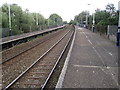
Trafford Park railway station, Greater Manchester
Opened 1904 by the Cheshire Lines Committee on the line from Manchester Central to Liverpool Central.
View west towards central Manchester.
Image: © Nigel Thompson
Taken: 21 Aug 2013
0.03 miles
2
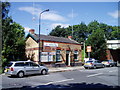
Trafford Park Station
The old ticket office is now used by a local taxi firm. Although named Trafford Park Station, access to Trafford Park industrial area is limited by the Bridgewater Canal and a railway siding.
Image: © R Greenhalgh
Taken: 7 Aug 2007
0.03 miles
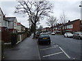
4
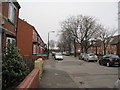
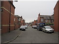
Kendal Road
Looking towards the railway lines.
Image: © Paddy Griffin
Taken: 14 Feb 2010
0.11 miles
5
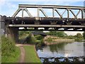
Waters Meeting
See also http://www.geograph.org.uk/search.php?i=14885957 . In the immediate foreground is a railway bridge. Beyond, the towpath bridge crosses the western arm of the Bridgewater Canal.
Image: © Derek Harper
Taken: 19 Aug 2010
0.12 miles
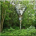
6
The vortex, Waters Meeting
This sculpture is apparently called The Vortex. It is adjacent to the canal towpath at Waters Meeting, the canal junction of the three branches of the Bridgewater Canal.
Image: © Graham Horn
Taken: 19 Aug 2007
0.12 miles
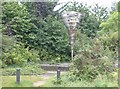
7
Overgrown Public Art
Close to the towpath at Waters Meeting of the Bridgewater Canal. There appears to be no information about this art.
Image: © Kevin Waterhouse
Taken: 9 May 2023
0.13 miles
9
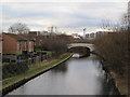
Bridge to nowhere
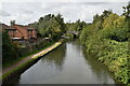
A view of the canal towards Kelloggs. The land to the right of the canal once was used by the Avro Company to build Lancaster bombers during WWII. Once the bridge carried Moss Road into Trafford Park, however the land now is used as warehousing for Kelloggs, which totally blocks the route. The only use for the bridge is a footpath carrying a public footpath.
Image: © Paddy Griffin
Taken: 12 Feb 2010
0.14 miles