IMAGES TAKEN NEAR TO
Arthur Street, MANCHESTER, M30 8QF
Introduction
This page details the photographs taken nearby to Arthur Street, M30 8QF by members of the Geograph project.
The Geograph project started in 2005 with the aim of publishing, organising and preserving representative images for every square kilometre of Great Britain, Ireland and the Isle of Man.

There are currently over 7.5m images from over14,400 individuals and you can help contribute to the project by visiting https://www.geograph.org.uk
Image Map
Images are licensed for reuse under creativecommons.org/licenses/by-sa/2.0
Notes
- Clicking on the map will re-center to the selected point.
- The higher the marker number, the further away the image location is from the centre of the postcode.
Image Listing (48 Images Found)
Images are licensed for reuse under creativecommons.org/licenses/by-sa/2.0
Image
Details
Distance
1
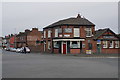
Packet House
A pub in a prominent position on the corner of Liverpool Road and Barton Road. It has a traditional appearance but does not sell real ale.
Image: © Bill Boaden
Taken: 5 Apr 2018
0.03 miles
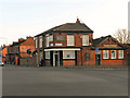
2
Packet House
Cut mark: Packet House SW side road centre NE face.
To the left of the black drain pipe below the black cable
Image: © Ian Charters
Taken: 19 Mar 2010
0.03 miles
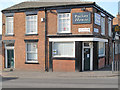
3
The Packet House
The Packet House, at the corner of Liverpool Road (A57) and Barton Road (B5211), at Patricroft, Eccles.
Image: © David Dixon
Taken: 6 Mar 2011
0.03 miles
4
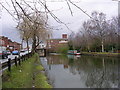
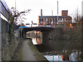
Bridgewater Canal
Looking roughly north along the Bridgewater Canal towpath. Patricroft Bridge carries the A57 road over the canal in the distance with Bridgewater Mill behind.
Image: © Keith Williamson
Taken: 7 Jan 2007
0.04 miles
5
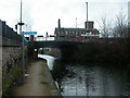
Bridgewater Canal, Liverpool Road Bridge
The bridge carrying Liverpool Road (A57) over the Bridgewater Canal at Patricroft, Eccles. The large building beyond the bridge is Image
Image: © David Dixon
Taken: 6 Mar 2011
0.04 miles
6
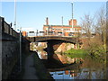
Patricroft, canal towpath
Towpaths were of course used by horses that pulled barges, & their owners; nowadays, they are a useful leisure facility. In front, road bridge carrying the Liverpool Road (A57) across the Bridgewater Canal, and in the distance, Bridgewater Mill Image For details of the canal, see http://www.bridgewatercanal.co.uk/
Image: © Mike Faherty
Taken: 23 Jan 2009
0.04 miles
7
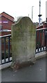
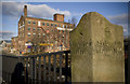
Old Milestone by the B5211, Worsley Road, Eccles parish
Carved stone post by the B5211, in parish of ECCLES (SALFORD District), Worsley Road, at junction with Liverpool Road, next to canal bridge, on Northwest corner of junction. Barton Stone, erected by the Barton Bridge & Moses Gate turnpike trust in the 19th century.
Inscription reads:-
: 8 / Miles to / Bolton : : 8 / Miles to / Altringham :
Milestone Society National ID: LA_BOAT08
Image: © Mike Faherty
Taken: 13 Jan 2011
0.05 miles
8
Bridgewater Canal, bridge 47 Patricroft
Image: © John Slater
Taken: 20 Jan 2014
0.05 miles
9
Barton and Moses Gate Turnpike Milestone
A milestone along the A57 Liverpool Road, through Eccles. This is at the junction with Worsley Road, and would appear to belong to the Barton Bridge and Moses Gate trust. Note the old spelling of 'Altringham' - latterly, 'Altrincham'.
Image: © Tom Jeffs
Taken: 28 Dec 2008
0.05 miles
10
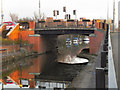
Bridgewater Canal, Liverpool Road Bridge
The bridge taking Liverpool Road over the Bridgewater Canal, at Eccles.
Image: © David Dixon
Taken: 6 Mar 2011
0.05 miles