IMAGES TAKEN NEAR TO
Stannard Road, MANCHESTER, M30 7PN
Introduction
This page details the photographs taken nearby to Stannard Road, M30 7PN by members of the Geograph project.
The Geograph project started in 2005 with the aim of publishing, organising and preserving representative images for every square kilometre of Great Britain, Ireland and the Isle of Man.

There are currently over 7.5m images from over14,400 individuals and you can help contribute to the project by visiting https://www.geograph.org.uk
Image Map
Images are licensed for reuse under creativecommons.org/licenses/by-sa/2.0
Notes
- Clicking on the map will re-center to the selected point.
- The higher the marker number, the further away the image location is from the centre of the postcode.
Image Listing (16 Images Found)
Images are licensed for reuse under creativecommons.org/licenses/by-sa/2.0
Image
Details
Distance
1
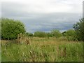
Brookhouse Community Woodland
A woodland project sponsored by the Cooperative Bank. Reclamation of a site formerly used as a municipal dump. Located close to the Eccles Interchange of the M60 motorway. Taken from SJ74889860 looking E.
Image: © Keith Williamson
Taken: 28 Aug 2005
0.12 miles
2
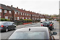
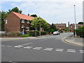
Foxhill Road
A residential street on the edge of the conurbation but there is no way through the houses.
Image: © Bill Boaden
Taken: 5 Apr 2018
0.13 miles
3
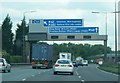
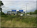
M60 Salford
Travelling clockwise along the M60 to the Mancunian equivalent of Spaghetti Junction with three motorways converging, which is frequently snarled up.
Image: © Andy Farrington
Taken: 20 Jun 2011
0.14 miles
4
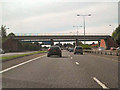
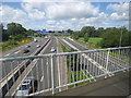
Rail Bridge Over M60, Eccles
Railway bridge between junctions 12 and 11 of the M60 at Eccles.
Image: © David Dixon
Taken: 4 Sep 2010
0.15 miles
6
Peel Green - Brookhouse Avenue Shops
Mostly shuttered and derelict.
Image: © Peter Whatley
Taken: 4 Jun 2009
0.17 miles
7
Eccles Interchange, J12, M60
A picture taken from SJ75139864 to the SW of the interchange. The interchange itself is almost centred on SJ750900 and is, therefore, a major feature of this grid squares and three others that meet there.
Image: © Keith Williamson
Taken: 28 Aug 2005
0.17 miles
8
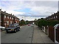
Brookhouse Estate, Eccles
A view looking S down Foxhill Road on Brookhouse Estate. A council housing estate built in the 1950's now suffering from the problems common to estates like this all over the country. (vandalism, gangs of aggressive youths intimidating older residents etc.)
Image: © Keith Williamson
Taken: 28 Aug 2005
0.17 miles
9
The M60 motorway
Manchester Outer Ringroad, looking towards the M62/M602 junction from a train crossing the motorway.
Image: © Thomas Nugent
Taken: 6 Jul 2020
0.17 miles
10
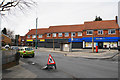
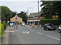
Shops on Brookhouse Avenue
The shops and the church to the left make up the centre of this housing estate.
Image: © Bill Boaden
Taken: 5 Apr 2018
0.18 miles