IMAGES TAKEN NEAR TO
Ampney Close, MANCHESTER, M30 7NL
Introduction
This page details the photographs taken nearby to Ampney Close, M30 7NL by members of the Geograph project.
The Geograph project started in 2005 with the aim of publishing, organising and preserving representative images for every square kilometre of Great Britain, Ireland and the Isle of Man.

There are currently over 7.5m images from over14,400 individuals and you can help contribute to the project by visiting https://www.geograph.org.uk
Image Map
Images are licensed for reuse under creativecommons.org/licenses/by-sa/2.0
Notes
- Clicking on the map will re-center to the selected point.
- The higher the marker number, the further away the image location is from the centre of the postcode.
Image Listing (24 Images Found)
Images are licensed for reuse under creativecommons.org/licenses/by-sa/2.0
Image
Details
Distance
2
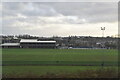
Patricroft from the air
The M60 and M602 run horizontally through the bottom of the photo, the M60 runs vertically on the left. They all meet at the junction in the lower left corner.
Image: © Thomas Nugent
Taken: 10 Nov 2014
0.10 miles