IMAGES TAKEN NEAR TO
Grand Union Way, MANCHESTER, M30 0LB
Introduction
This page details the photographs taken nearby to Grand Union Way, M30 0LB by members of the Geograph project.
The Geograph project started in 2005 with the aim of publishing, organising and preserving representative images for every square kilometre of Great Britain, Ireland and the Isle of Man.

There are currently over 7.5m images from over14,400 individuals and you can help contribute to the project by visiting https://www.geograph.org.uk
Image Map
Images are licensed for reuse under creativecommons.org/licenses/by-sa/2.0
Notes
- Clicking on the map will re-center to the selected point.
- The higher the marker number, the further away the image location is from the centre of the postcode.
Image Listing (96 Images Found)
Images are licensed for reuse under creativecommons.org/licenses/by-sa/2.0
Image
Details
Distance
1
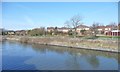
Open space off Caledonian Drive
On the north bank of the Manchester Ship Canal.
Image: © Christine Johnstone
Taken: 13 Apr 2013
0.07 miles
2
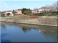
Houses on Caledonian Drive
On the north bank of the Manchester Ship Canal.
Image: © Christine Johnstone
Taken: 13 Apr 2013
0.09 miles
3
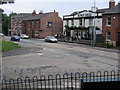
The Kings Head Public House
At the junction of Trafford Rd. with Barton Lane.
Image: © David Newton
Taken: 29 Jun 2009
0.14 miles
4
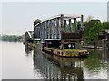
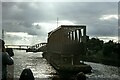
Manchester Ship Canal, Barton Swing Aqueduct
Image: © David Dixon
Taken: 11 May 2016
0.17 miles
5
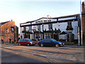
Kings Head
The Kings Head public house on Barton Lane, Patricroft.
Image: © David Dixon
Taken: 6 Mar 2011
0.17 miles
6
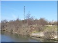
Support for air draft gauge, Manchester Ship Canal
A wire is slung between two towers on opposite banks of the canal. If a ship touches the wire, it is too tall to fit under a nearby bridge.
Image: © Christine Johnstone
Taken: 13 Apr 2013
0.17 miles
7
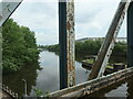
Manchester Ship Canal from the Barton Swing Aqueduct
A boater's view.
Image: © Christine Johnstone
Taken: 29 May 2021
0.17 miles
8
Barton swing aqueduct
The vessel arrives, just two minutes after the road bridge had been swung. This is a regular passenger trip, every Sunday, along the ship canal, complete with commentary. The trip runs upstream one week and downstream the next. This downstream trip we would have expected to go follow the right hand channel (rule of the waterway keep right) but it went left, the far side from us. Oh well (or should that be Irwell?)
Next picture Image]
Image: © Graham Horn
Taken: 19 Aug 2007
0.18 miles
9
Barton Road Bridge and Swing Aqueduct ? 1978
Taken during one of the Mersey Ferries regular cruises along the Manchester Ship Canal. Looking back after passing through. The road bridge is already being swung back in favour of road traffic.
The whole complex of bridge, aqueduct and control tower is Listed Grade II*.
Image: © Alan Murray-Rust
Taken: Unknown
0.19 miles
10
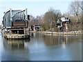
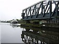
Barton Swing Aqueduct
Swung open in favour of a boat coming from Manchester on the Manchester Ship Canal.
Image: © Christine Johnstone
Taken: 13 Apr 2013
0.19 miles