IMAGES TAKEN NEAR TO
Peel Lane, MANCHESTER, M29 7QZ
Introduction
This page details the photographs taken nearby to Peel Lane, M29 7QZ by members of the Geograph project.
The Geograph project started in 2005 with the aim of publishing, organising and preserving representative images for every square kilometre of Great Britain, Ireland and the Isle of Man.

There are currently over 7.5m images from over14,400 individuals and you can help contribute to the project by visiting https://www.geograph.org.uk
Image Map
Images are licensed for reuse under creativecommons.org/licenses/by-sa/2.0
Notes
- Clicking on the map will re-center to the selected point.
- The higher the marker number, the further away the image location is from the centre of the postcode.
Image Listing (46 Images Found)
Images are licensed for reuse under creativecommons.org/licenses/by-sa/2.0
Image
Details
Distance
1
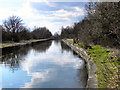
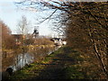
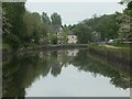
Bridgewater Canal, Astley Green
Looking west, along the Bridgewater Canal, from Peel Lane at Astley Green.
Image: © David Dixon
Taken: 19 Mar 2011
0.11 miles
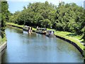
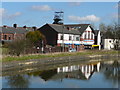
4
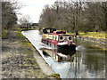
Bridgewater Canal
A narrowboat on the Bridgewater Canal, between Town Lane and Astley.
Image: © David Dixon
Taken: 19 Mar 2011
0.13 miles
9
Red traffic light at Astley Bridge
On First Avenue, not the Bridgewater Canal.
Image: © Christine Johnstone
Taken: 29 May 2021
0.17 miles
10
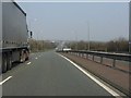
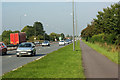
A580 heads across Lancashire
Viewed from the Bridgewater Canal bridge, the East Lancashire Road runs straight across the south Lancashire plain towards Boothstown.
Image: © Peter Whatley
Taken: 24 Mar 2011
0.17 miles