IMAGES TAKEN NEAR TO
Dunmail Close, MANCHESTER, M29 7JN
Introduction
This page details the photographs taken nearby to Dunmail Close, M29 7JN by members of the Geograph project.
The Geograph project started in 2005 with the aim of publishing, organising and preserving representative images for every square kilometre of Great Britain, Ireland and the Isle of Man.

There are currently over 7.5m images from over14,400 individuals and you can help contribute to the project by visiting https://www.geograph.org.uk
Image Map
Images are licensed for reuse under creativecommons.org/licenses/by-sa/2.0
Notes
- Clicking on the map will re-center to the selected point.
- The higher the marker number, the further away the image location is from the centre of the postcode.
Image Listing (20 Images Found)
Images are licensed for reuse under creativecommons.org/licenses/by-sa/2.0
Image
Details
Distance
1
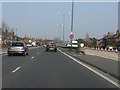
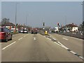
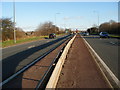
A580 east of Higher Green junction
The arrangement of access roads and housing either side of the main carriageways gives some idea of how the A580 might have looked had its original design been followed. See: http://www.lancashire.gov.uk/environment/historichighways/eastlancs/index.asp for details.
Image: © Peter Whatley
Taken: 24 Mar 2011
0.05 miles
2
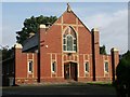
Astley Independent Methodist Church
Astley Independent Methodist Church, Manchester Road, Astley.
Image: © Julian Graham
Taken: 25 Sep 2005
0.05 miles
4
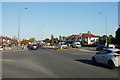
East Lancashire Road (A580)
Looking towards Manchester along the East Lancashire Road from the junction with Higher Green Lane.
Image: © David Dixon
Taken: 19 Mar 2011
0.09 miles
6
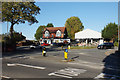
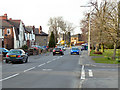
The top of Higher Green Lane
Where it meets Manchester Road, the A572. Coach Road starts opposite. This junction can get very busy in rush hours.
Image: © Bill Boaden
Taken: 18 Oct 2018
0.11 miles
7
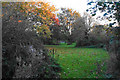
Recreation ground in Astley
A surprisingly secluded area of open access land in Astley. A footpath runs straight ahead though you cannot tell.
Image: © Bill Boaden
Taken: 18 Oct 2018
0.13 miles
8
A service road by the East Lancs Road at Astley
Image: © Ian Greig
Taken: 9 Aug 2010
0.13 miles
9
The East Lancs Road looking north east
Looking towards the crossroads at Higher Green Astley.
Image: © SMJ
Taken: 26 Dec 2008
0.14 miles
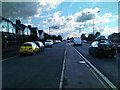
10
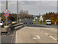
Crossroads on the East Lancs Road
Higher Green Lane crosses the A580 here.
Image: © Bill Boaden
Taken: 18 Oct 2018
0.14 miles